✅Ohio County Map
Ohio is organized into a network of counties that shape daily life, from local roads and courts to parks and public records. Understanding these counties – and their county seats – makes it much easier to read maps, follow local news, plan travel, or simply get a clearer picture of how this Midwestern state is structured.
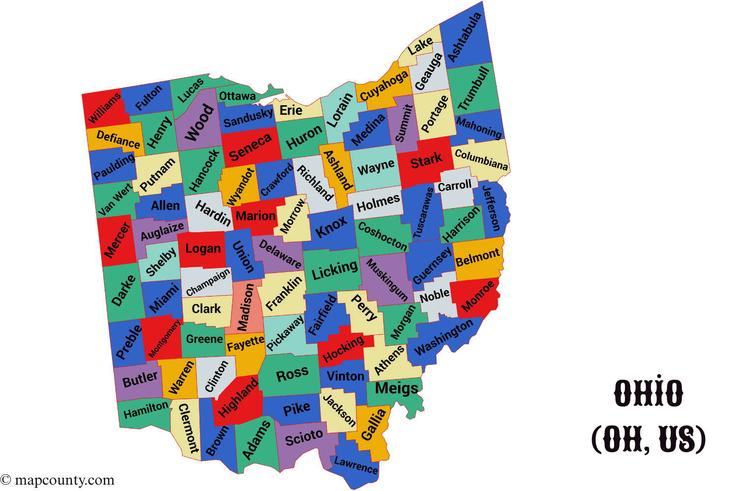
Quick snapshot of Ohio counties
- Total counties: 88
- Most populous county: Franklin County (home to Columbus)
- Largest by land area: Ashtabula County in the northeast
- Smallest by land area: Lake County along Lake Erie
- Oldest county: Washington County (created in 1788)
- Youngest county: Noble County (created in 1851)
Full List of Ohio Counties and County Seats
The table below lists all 88 counties in Ohio together with their county seats. County seats are the main administrative centers where you usually find the courthouse, key county offices, and many public services.
| # | County | County seat |
|---|---|---|
| 1 | Adams County | West Union |
| 2 | Allen County | Lima |
| 3 | Ashland County | Ashland |
| 4 | Ashtabula County | Jefferson |
| 5 | Athens County | Athens |
| 6 | Auglaize County | Wapakoneta |
| 7 | Belmont County | St. Clairsville |
| 8 | Brown County | Georgetown |
| 9 | Butler County | Hamilton |
| 10 | Carroll County | Carrollton |
| 11 | Champaign County | Urbana |
| 12 | Clark County | Springfield |
| 13 | Clermont County | Batavia |
| 14 | Clinton County | Wilmington |
| 15 | Columbiana County | Lisbon |
| 16 | Coshocton County | Coshocton |
| 17 | Crawford County | Bucyrus |
| 18 | Cuyahoga County | Cleveland |
| 19 | Darke County | Greenville |
| 20 | Defiance County | Defiance |
| 21 | Delaware County | Delaware |
| 22 | Erie County | Sandusky |
| 23 | Fairfield County | Lancaster |
| 24 | Fayette County | Washington Court House |
| 25 | Franklin County | Columbus |
| 26 | Fulton County | Wauseon |
| 27 | Gallia County | Gallipolis |
| 28 | Geauga County | Chardon |
| 29 | Greene County | Xenia |
| 30 | Guernsey County | Cambridge |
| 31 | Hamilton County | Cincinnati |
| 32 | Hancock County | Findlay |
| 33 | Hardin County | Kenton |
| 34 | Harrison County | Cadiz |
| 35 | Henry County | Napoleon |
| 36 | Highland County | Hillsboro |
| 37 | Hocking County | Logan |
| 38 | Holmes County | Millersburg |
| 39 | Huron County | Norwalk |
| 40 | Jackson County | Jackson |
| 41 | Jefferson County | Steubenville |
| 42 | Knox County | Mount Vernon |
| 43 | Lake County | Painesville |
| 44 | Lawrence County | Ironton |
| 45 | Licking County | Newark |
| 46 | Logan County | Bellefontaine |
| 47 | Lorain County | Elyria |
| 48 | Lucas County | Toledo |
| 49 | Madison County | London |
| 50 | Mahoning County | Youngstown |
| 51 | Marion County | Marion |
| 52 | Medina County | Medina |
| 53 | Meigs County | Pomeroy |
| 54 | Mercer County | Celina |
| 55 | Miami County | Troy |
| 56 | Monroe County | Woodsfield |
| 57 | Montgomery County | Dayton |
| 58 | Morgan County | McConnelsville |
| 59 | Morrow County | Mount Gilead |
| 60 | Muskingum County | Zanesville |
| 61 | Noble County | Caldwell |
| 62 | Ottawa County | Port Clinton |
| 63 | Paulding County | Paulding |
| 64 | Perry County | New Lexington |
| 65 | Pickaway County | Circleville |
| 66 | Pike County | Waverly |
| 67 | Portage County | Ravenna |
| 68 | Preble County | Eaton |
| 69 | Putnam County | Ottawa |
| 70 | Richland County | Mansfield |
| 71 | Ross County | Chillicothe |
| 72 | Sandusky County | Fremont |
| 73 | Scioto County | Portsmouth |
| 74 | Seneca County | Tiffin |
| 75 | Shelby County | Sidney |
| 76 | Stark County | Canton |
| 77 | Summit County | Akron |
| 78 | Trumbull County | Warren |
| 79 | Tuscarawas County | New Philadelphia |
| 80 | Union County | Marysville |
| 81 | Van Wert County | Van Wert |
| 82 | Vinton County | McArthur |
| 83 | Warren County | Lebanon |
| 84 | Washington County | Marietta |
| 85 | Wayne County | Wooster |
| 86 | Williams County | Bryan |
| 87 | Wood County | Bowling Green |
| 88 | Wyandot County | Upper Sandusky |
How the County System Shapes Ohio
Think of Ohio as a collection of 88 counties. Each county has its own local leaders and offices, yet they all follow state law and operate within the same system. While each county has its own character, they share some common roles.
- County commissioners handle budgets, buildings, and many local services.
- County sheriffs oversee law enforcement at the county level.
- Auditors and treasurers deal with property records and taxes.
- Engineers focus on roads, bridges, and infrastructure within the county.
- Clerks of courts manage important legal records and documents.
Because counties are closer to residents than the state goverment, people often interact with their county when they register a vehicle, file land records, or attend a local court hearing. That makes the name of your county – and its seat – more useful than it may look at first glance.
Regional Patterns Across Ohio Counties
Northern & lakeshore counties
Counties along Lake Erie, such as Lucas (Toledo), Lorain (Elyria), Lake (Painesville), and Ashtabula (Jefferson), blend port activity, industry, and tourism. Lake views, beaches, and maritime services are common parts of life there.
Central counties
At the center of the state, Franklin County (Columbus) stands out with state institutions, major employers, and universities. Surrounding counties such as Delaware, Licking and Union mix growing suburbs with farmland and small towns.
Southwest & Miami Valley
Hamilton County (Cincinnati), Butler County (Hamilton), and Montgomery County (Dayton) anchor a dense band of cities and suburbs. These counties play a big role in manufacturing, logistics, healthcare, and higher education.
Appalachian southeast
Southeastern counties such as Athens, Meigs, Gallia, Vinton, and Washington are more rural, with hills, forests, and river valleys. Here, local culture is shaped by outdoor activities, small-town life, and long-standing community traditions.
Across all these regions, county seats act like compact hubs. They bring together schools, hospitals, small businesses, and public buildings in a single focal point, often just a short drive from surrounding villages and townships.
Population and Land: How Counties Differ
Even though Ohio is not one of the largest states by area, its counties vary a lot in both size and population. The average county covers a little over 460 square miles, but the range is wide: from compact Lake County to spacious Ashtabula County on the northeastern edge of the state.
Examples of contrast between counties
- Franklin County (Columbus) has a large urban population and dense development.
- Vinton County is one of the least populated counties, with more forests and open land.
- Ashtabula County stretches far across the northeast, with wineries, farms, and lake shoreline.
- Lake County packs people, industry, and lakefront neighborhoods into a relatively small area.
Urban, suburban, and rural character
Not every county feels the same. Some are strongly urban, with tall buildings and busy highways. Others are mainly farmland or forest. Many sit somewhere in the middle.
- Urban focus: counties like Cuyahoga (Cleveland), Franklin (Columbus), Hamilton (Cincinnati), and Summit (Akron) are built around large cities.
- Suburban mix: counties such as Delaware, Warren, and Medina have fast-growing suburbs, shopping areas, and business parks beside residential neighborhoods.
- Rural strength: places like Holmes, Highland, Meigs, or Monroe are known for agriculture, forests, and small towns.
This variety makes Ohio flexible. Businesses can choose between busy metro centers, quiet countryside, or something in between, all within a few hours’ drive.
County Life: Services, Schools, and Daily Needs
When someone moves to Ohio or plans a visit, they often ask simple questions: Which county am I in? Where is the courthouse? Which county office handles my records? Knowing your county answers these quickly.
What counties typically manage
- Property tax assessment and records
- Local courts and some legal filings
- Vital records in some areas (such as marriage licenses)
- Parts of the road network and bridges
- Emergency services coordination
Everyday situations where county names matter
- Checking school districts and attendance zones
- Looking up zoning and land-use rules
- Searching for local public health information
- Planning road trips through several counties
- Doing family history research using county archives
Because Ohio’s counties are clearly defined, it is easier to divide services and responsibilities. Whether you live in busy Franklin County or quiet Vinton County, you still have a county seat where key offices and records are concentrated.
Spotlight on a Few Notable Ohio Counties
While every county has its own story, a few stand out because of their role in the state’s economy, history, or geography.
- Franklin County (Columbus) – State capital, major universities, diverse neighborhoods, and a strong service-based economy.
- Cuyahoga County (Cleveland) – Historic industrial center on Lake Erie with healthcare, culture, and lakefront parks.
- Hamilton County (Cincinnati) – Key role in finance, logistics, arts, and sports for southwest Ohio and nearby regions.
- Ashtabula County (Jefferson) – Largest county by area, known for vineyards, rural landscapes, and lake shoreline.
- Holmes County (Millersburg) – Famous for Amish communities, handcrafted goods, and scenic back roads.
- Washington County (Marietta) – The oldest county, located at the meeting of the Muskingum and Ohio Rivers, with rich early-state history.
Reading and Using County Data More Effectively
County information can look technical at first – lists of names, numbers, and dates. Once you know what to look for, it becomes a clear, helpful tool instead of a puzzle.
- County name tells you the local unit of government responsible for many services.
- County seat points to the town or city where the courthouse and central offices are located.
- Creation year (when available) hints at the county’s age and sometimes its historical background.
- Area and population show how densely people live and how far services may be spread out.
- Region within Ohio (north, central, south, Appalachian, lakeshore) helps you imagine climate, landscape, and typical local activities.
Next time you come across a city like Akron, Toledo, or Chillicothe, asking a simple question – “Which county is this in?” – gives you instant context. From there, the county list at the top of this page becomes a quick reference you can rely on instead of a long, confusing adress list.
More USA County Maps
- South Dakota County Map with Cities and Towns [SD, US]
- South Carolina County Map with Cities and Towns [SC, US]
- North Carolina County Map with Cities and Towns [NC, US]
- North Dakota County Map with Cities and Towns [ND, US]
- Wyoming County Map with Cities and Towns [WY, US]
- Wisconsin County Map with Cities and Towns [WI, US]