Nevada • County Map • Cities & Towns
Nevada County Map with Cities and Towns (NV, USA)
Use this detailed Nevada county map with cities and towns to explore all
17 county-level jurisdictions across the Silver State – from Las Vegas and Reno
to tiny desert communities in the Great Basin.
Great for trip planning, school projects, real-estate research, logistics, or simply understanding how Nevada is organized on the map.
🗺️ Quick Map Tip
Zoom in until county borders are clear, then click a county to connect its
lines with real cities, towns, highways, and valleys you see on the ground.
Interactive Nevada County Map
Tip: try full-screen on mobile and pan along I-15, I-80 and US-95 to see how cities and towns line up with county borders.
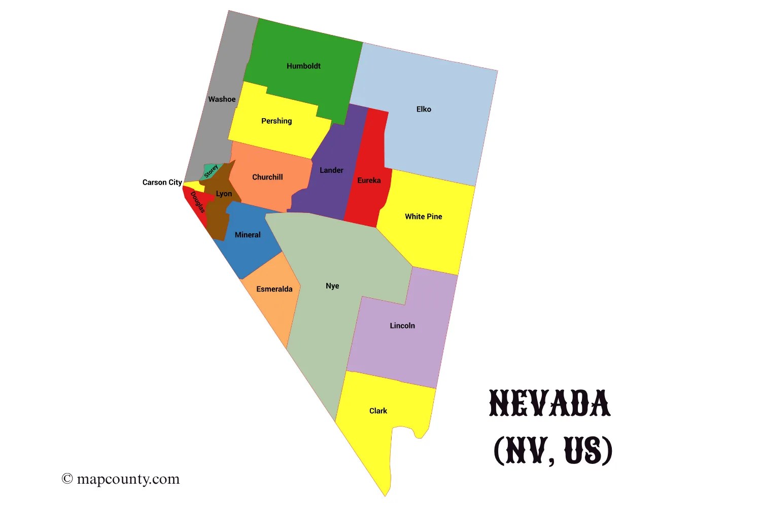
Complete Nevada County List (16 Counties + Carson City)
Nevada is divided into 17 county-level jurisdictions: 16 counties plus
Carson City, a consolidated municipality that functions as an independent city and county equivalent.
The table below lists each county, its type, and its county seat so you can match names directly to the map.
| # | County / Jurisdiction | Type | County Seat / Capital | General Region |
|---|---|---|---|---|
| 1 | Carson City | Independent city / county-equivalent | Carson City | Western Nevada, at the base of the Sierra Nevada |
| 2 | Churchill County | County | Fallon | West-central Nevada, Lahontan Valley |
| 3 | Clark County | County | Las Vegas | Southern Nevada, Mojave Desert & Las Vegas Valley |
| 4 | Douglas County | County | Minden | Far west, Carson Valley & Lake Tahoe area |
| 5 | Elko County | County | Elko | Northeastern Nevada, Great Basin ranges |
| 6 | Esmeralda County | County | Goldfield | South-central, sparsely populated desert & mining areas |
| 7 | Eureka County | County | Eureka | Central Nevada, mountain basins and mining corridor |
| 8 | Humboldt County | County | Winnemucca | North-central, along I-80 and Humboldt River |
| 9 | Lander County | County | Battle Mountain | Central Nevada, between I-80 and US-50 |
| 10 | Lincoln County | County | Pioche | Southeastern Nevada, near Utah border |
| 11 | Lyon County | County | Yerington | Western Nevada, between Carson City and Fallon |
| 12 | Mineral County | County | Hawthorne | West-central Nevada, Walker Lake area |
| 13 | Nye County | County | Tonopah | South-central Nevada; largest county by land area |
| 14 | Pershing County | County | Lovelock | North-central, including parts of the Black Rock Desert |
| 15 | Storey County | County | Virginia City | Western Nevada, historic Comstock Lode mining district |
| 16 | Washoe County | County | Reno | Northwestern Nevada, Truckee Meadows & Lake Tahoe shore |
| 17 | White Pine County | County | Ely | East-central Nevada, high basins near Utah border |
When you click around the Nevada county map, you can use this table to confirm county names, seats,
and which part of the state you’re looking at.
How Nevada Is Organized on the Map
Nevada stretches across the Great Basin and edge of the Mojave Desert. On this county map
you can immediately see the contrast between:
Dense urban counties in the south & west
- Clark County (Las Vegas Valley & Henderson, North Las Vegas, Boulder City).
- Washoe County (Reno–Sparks, Truckee Meadows).
- Carson City and nearby Douglas and Lyon counties in the Sierra foothills.
Vast rural counties across the interior
- Nye County, the largest by land area, covering huge deserts and mountain ranges.
- Elko, White Pine, Humboldt and others in the high Great Basin.
- Esmeralda, Lincoln, Eureka and Mineral with scattered mining and ranching towns.
Zooming out, Nevada’s 17 county-level areas frame major corridors like I-15, I-80, US-95 and the
Truckee and Colorado river valleys. Zooming in shows how mountains, dry lakes, and basins
shape the edges of county lines.
Nevada’s Main Regions on the County Map
For orientation, many travelers and geographers break Nevada into three broad areas that align closely with county
boundaries and communities:
Southern Nevada & the Las Vegas Valley
Centered on Clark County, this region includes Las Vegas, Henderson, North Las Vegas, Boulder City
and rapidly growing suburbs. On the map, it is a compact cluster of urban areas in the far south of the state.
Western Nevada & the Sierra Front
Washoe County, Carson City, Douglas, Lyon, Churchill and Mineral line the eastern
slope of the Sierra Nevada and surrounding basins. This is where you find Reno, Sparks, Carson City, and communities
around Lake Tahoe and Fallon.
Central & Northern Great Basin
Counties like Nye, Elko, White Pine, Humboldt, Lander, Eureka, Lincoln, Esmeralda and
Pershing cover long mountain ranges and high valleys with small but important towns along key highways.
Major Cities and Towns You’ll See on the Nevada Map
The Nevada county map with cities and towns shows a big contrast between a few large urban centers and
many small communities scattered across the desert and mountains.
- Las Vegas – Largest city in Nevada and county seat of
Clark County, close to Henderson & North Las Vegas. - Henderson & North Las Vegas – Major suburban cities in Clark County that
blend into the Las Vegas metro area on the map. - Reno–Sparks – Urban pair in Washoe County, along the Truckee River.
- Carson City – State capital and independent city along the eastern Sierra front.
- Elko – Hub for northeastern Nevada in Elko County, surrounded by mining and ranching towns.
- Fallon, Fernley, Yerington, Minden – Key small cities in western counties (Churchill, Lyon, Douglas).
- Tonopah, Pahrump, Ely, Winnemucca – Anchor towns for large rural counties like Nye, White Pine, and Humboldt.
- Historic communities – Virginia City in Storey County and
smaller mining towns appear when you zoom in further.
Looking at cities through the lens of counties helps you see commuting patterns, metro areas and where services such as
hospitals, colleges and airports are concentrated.
Using the Nevada County Map in Real Life
Travel & road trips
- Trace I-15 from Las Vegas toward Utah and see which counties you cross.
- Follow I-80 through Washoe, Pershing, Humboldt and Elko counties toward Utah.
- Use county names to find fuel, lodging and services along long stretches of US-95 or US-50.
School projects & research
- Connect county boundaries with mining, ranching and tourism regions.
- Overlay climate, geology or demographic data from official sources onto the county grid.
- Compare urban counties (Clark, Washoe) with lightly populated ones like Esmeralda or Eureka.
Relocation & real estate
- Compare housing markets and lifestyles in Clark, Washoe and smaller western counties.
- Understand which county and services you’d rely on if you move to a rural town.
- Match school districts, taxes and commuting distances to county lines.
Business & logistics
- Define sales territories or service zones by county.
- Plan deliveries across sparsely populated counties where distances between towns are large.
- Combine county boundaries with Census data for market analysis and infrastructure planning.
FAQ: Nevada Counties, Cities and Towns
How many county-level areas are in Nevada?
Nevada has 16 counties plus Carson City, an independent city that is treated as a county-equivalent.
Together they form 17 county-level jurisdictions that cover the entire state.
Which county is largest and which is smallest?
Nye County is Nevada’s largest county by land area, covering more than 18,000 square miles. By contrast,
Storey County is the smallest county by land area, while Carson City is the smallest county-equivalent overall.
Which county has the most people?
Clark County, anchored by Las Vegas and its suburbs, is by far the most populous county in Nevada. It holds
the majority of the state’s residents and a large share of its jobs and services.
What is special about Carson City?
Carson City is Nevada’s state capital and a consolidated municipality. That means the city and county
governments are merged, so Carson City acts as both a city and a county-equivalent on maps and in federal statistics.
References
For deeper research, official boundaries, and downloadable GIS data related to Nevada counties and cities, these
authoritative sources are especially useful:
Nevada County Boundaries – Nevada state GIS (ArcGIS Hub)
State of Nevada – Department of Transportation County Boundaries Map Service
U.S. Census Bureau – TIGER/Line Shapefiles (county and county-equivalent boundaries)
GISGeography – Nevada County Map and Independent City (list of 16 counties + Carson City)
Nevada Counties & Independent Cities – Hometown Locator (cities & towns by county)
More USA County Maps
- South Dakota County Map with Cities and Towns [SD, US]
- South Carolina County Map with Cities and Towns [SC, US]
- North Carolina County Map with Cities and Towns [NC, US]
- North Dakota County Map with Cities and Towns [ND, US]
- Wyoming County Map with Cities and Towns [WY, US]
- Wisconsin County Map with Cities and Towns [WI, US]