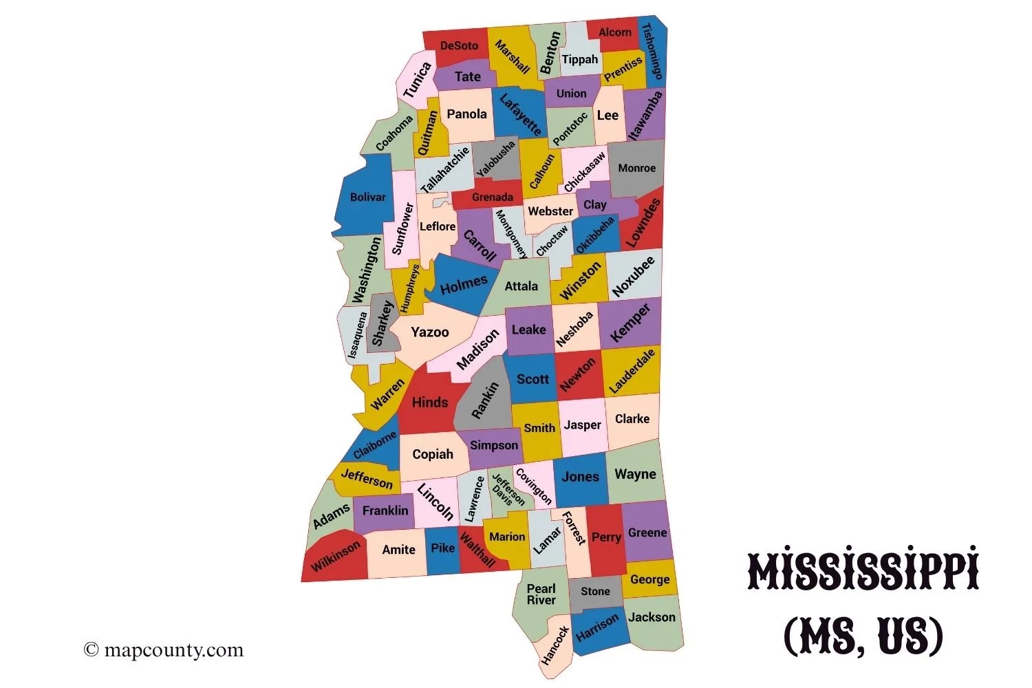
✅Mississippi County Map
✅Mississippi County List with Cities and Towns
So, Mississippi has 82 counties, right? Well, here’s the full rundown. It tells you where the county seat is, how much space it covers, and all the important spots.
| County Name | County Seat(s) | Major Cities & Towns |
|---|---|---|
| Adams | Natchez | Natchez |
| Alcorn | Corinth | Corinth, Glen |
| Amite | Liberty | Liberty, Gloster |
| Attala | Kosciusko | Kosciusko |
| Benton | Ashland | Ashland |
| Bolivar | Rosedale & Cleveland | Cleveland, Rosedale, Shaw |
| Calhoun | Pittsboro | Calhoun City, Bruce |
| Carroll | Carrollton & Vaiden | Carrollton, Vaiden |
| Chickasaw | Houston & Okolona | Houston, Okolona |
| Choctaw | Ackerman | Ackerman, Weir |
| Claiborne | Port Gibson | Port Gibson |
| Clarke | Quitman | Quitman, Shubuta |
| Clay | West Point | West Point |
| Coahoma | Clarksdale | Clarksdale, Friars Point |
| Copiah | Hazlehurst | Hazlehurst, Crystal Springs |
| Covington | Collins | Collins, Seminary |
| DeSoto | Hernando | Southaven, Olive Branch, Horn Lake |
| Forrest | Hattiesburg | Hattiesburg, Petal |
| Franklin | Meadville | Meadville, Bude |
| George | Lucedale | Lucedale |
| Greene | Leakesville | Leakesville |
| Grenada | Grenada | Grenada |
| Hancock | Bay St. Louis | Bay St. Louis, Waveland, Diamondhead |
| Harrison | Gulfport & Biloxi | Gulfport, Biloxi, Long Beach |
| Hinds | Jackson & Raymond | Jackson, Clinton, Byram |
| Holmes | Lexington | Lexington, Durant |
| Humphreys | Belzoni | Belzoni, Isola |
| Issaquena | Mayersville | Mayersville |
| Itawamba | Fulton | Fulton |
| Jackson | Pascagoula | Pascagoula, Ocean Springs, Moss Point |
| Jasper | Bay Springs & Paulding | Bay Springs, Heidelberg |
| Jefferson | Fayette | Fayette |
| Jefferson Davis | Prentiss | Prentiss |
| Jones | Laurel & Ellisville | Laurel, Ellisville |
| Kemper | De Kalb | De Kalb |
| Lafayette | Oxford | Oxford, Abbeville |
| Lamar | Purvis | Purvis, Lumberton, Sumrall |
| Lauderdale | Meridian | Meridian, Marion |
| Lawrence | Monticello | Monticello |
| Leake | Carthage | Carthage, Walnut Grove |
| Lee | Tupelo | Tupelo, Saltillo, Verona |
| Leflore | Greenwood | Greenwood, Itta Bena |
| Lincoln | Brookhaven | Brookhaven |
| Lowndes | Columbus | Columbus, Caledonia |
| Madison | Canton | Madison, Ridgeland, Canton |
| Marion | Columbia | Columbia |
| Marshall | Holly Springs | Holly Springs, Byhalia |
| Monroe | Aberdeen | Aberdeen, Amory |
| Montgomery | Winona | Winona, Duck Hill |
| Neshoba | Philadelphia | Philadelphia |
| Newton | Decatur | Newton, Union |
| Noxubee | Macon | Macon, Brooksville |
| Oktibbeha | Starkville | Starkville, Maben |
| Panola | Sardis & Batesville | Batesville, Sardis, Como |
| Pearl River | Poplarville | Picayune, Poplarville |
| Perry | New Augusta | New Augusta, Richton |
| Pike | Magnolia | McComb, Magnolia |
| Pontotoc | Pontotoc | Pontotoc, Ecru |
| Prentiss | Booneville | Booneville, Baldwyn |
| Quitman | Marks | Marks, Lambert |
| Rankin | Brandon | Brandon, Pearl, Flowood |
| Scott | Forest | Forest, Morton |
| Sharkey | Rolling Fork | Rolling Fork, Anguilla |
| Simpson | Mendenhall | Mendenhall, Magee |
| Smith | Raleigh | Raleigh |
| Stone | Wiggins | Wiggins |
| Sunflower | Indianola | Indianola, Ruleville |
| Tallahatchie | Charleston & Sumner | Charleston, Sumner |
| Tate | Senatobia | Senatobia, Coldwater |
| Tippah | Ripley | Ripley, Walnut |
| Tishomingo | Iuka | Iuka, Tishomingo |
| Tunica | Tunica | Tunica, Tunica Resorts |
| Union | New Albany | New Albany |
| Walthall | Tylertown | Tylertown |
| Warren | Vicksburg | Vicksburg |
| Washington | Greenville | Greenville, Leland |
| Wayne | Waynesboro | Waynesboro |
| Webster | Walthall | Eupora, Walthall |
| Wilkinson | Woodville | Woodville, Centreville |
| Winston | Louisville | Louisville |
| Yalobusha | Water Valley & Coffeeville | Water Valley, Coffeeville |
| Yazoo | Yazoo City | Yazoo City, Bentonia |
A Guide to Mississippi’s Counties
Welcome to the Magnolia State! Mississippi, a state defined by its rich history, vibrant culture, and lush landscapes, is administratively divided into 82 counties. This structure forms the backbone of local governance and community identity, from the bustling streets of Jackson to the quiet, rolling hills of the countryside. Whether you’re a genealogist, a student, a traveler, or a business owner, understanding this county map is the first step to truly exploring Mississippi.
Each county, with its unique seat (or sometimes two!), serves as a hub for its residents, housing courthouses, vital records, and local services. These counties are home to a diverse array of municipalities, which Mississippi law classifies by population:
- Cities: Municipalities with 2,000 or more inhabitants.
- Towns: Municipalities with 300 to 1,999 inhabitants.
- Villages: Municipalities with 100 to 299 inhabitants.
This guide covers Mississippi’s 82 counties, their county seats, and some of the cities and towns that define each area. Note: The “Major Cities & Towns” column includes important populated places but is not a complete list.
A Deeper Dive: Navigating the Regions
Mississippi’s counties are often grouped into distinct regions, each with its own character. The most famous of these is the Mississippi Delta (not to be confused with the Mississippi River’s delta in Louisiana). This region, located in the northwestern part of the state, is an alluvial plain known for its fertile soil, agricultural history, and as the birthplace of the Blues. Counties like Bolivar, Coahoma, Leflore, Sunflower, and Washington are central to this iconic area.
Other regions include:
- The Gulf Coast: Home to Harrison, Hancock, and Jackson counties, this region is a center for tourism, gaming, and seafood industries, with major cities like Gulfport and Biloxi.
- The Pines: Covering much of the southern and eastern parts of the state, this region was historically dominated by longleaf pine forests. Forrest County, home to Hattiesburg, is a major hub.
- The Hills: Located in North Mississippi, this region includes counties like Lafayette (where Oxford and the University of Mississippi are) and Lee (where Tupelo, the birthplace of Elvis Presley, is).
- The Capital Region: Centered on Hinds, Rankin, and Madison counties, this is the state’s most populous metropolitan area, anchored by the capital city of Jackson.
Using County Maps for Your Journey
Why is a county map so essential? For starters, it’s a vital tool for genealogy research. Vital records—birth, marriage, death, and property deeds—are all filed at the county level. Knowing the correct county is the key to unlocking your family’s history.
For travelers and explorers, the county map reveals the real Mississippi. It guides you off the interstate and into historic courthouse squares, local festivals, and scenic backroads. It helps you discover the small towns and cities that are the heart of the state’s culture.
For businesses and planners, county data is the foundation for understanding demographics, infrastructure, and economic trends. A detailed map provides critical context for growth and development.
We hope this guide helps you start your exploration of Mississippi. Each county has its own story, and together they make up the unique character of the Magnolia State.
References
To ensure the accuracy and depth of your research, we recommend consulting these official government and university resources:
- U.S. Census Bureau – Mississippi QuickFacts: The primary source for detailed population, demographic, and economic data for every county and city in Mississippi.https://www.census.gov/quickfacts/fact/table/MS/PST045223
- Mississippi Secretary of State – Municipal Government: A detailed PDF explaining the legal classification of cities, towns, and villages in the state.https://www.sos.ms.gov/content/documents/ed_pubs/pubs/BlueBook20-24/12%20Municipal%20Government.pdf
- Mississippi State University Extension Service – County Offices: A complete, interactive directory of all 82 county extension offices, a valuable resource for local agricultural and community data.https://extension.msstate.edu/county-offices
- MARIS (Mississippi Automated Resource Information System): The state’s official clearinghouse for geospatial (GIS) data, offering downloadable datasets and interactive maps for boundaries, transportation, and more.https://maris.mississippi.edu/HTML/Data.html
More USA County Maps
- South Dakota County Map with Cities and Towns [SD, US]
- South Carolina County Map with Cities and Towns [SC, US]
- North Carolina County Map with Cities and Towns [NC, US]
- North Dakota County Map with Cities and Towns [ND, US]
- Wyoming County Map with Cities and Towns [WY, US]
- Wisconsin County Map with Cities and Towns [WI, US]