Maryland County Map
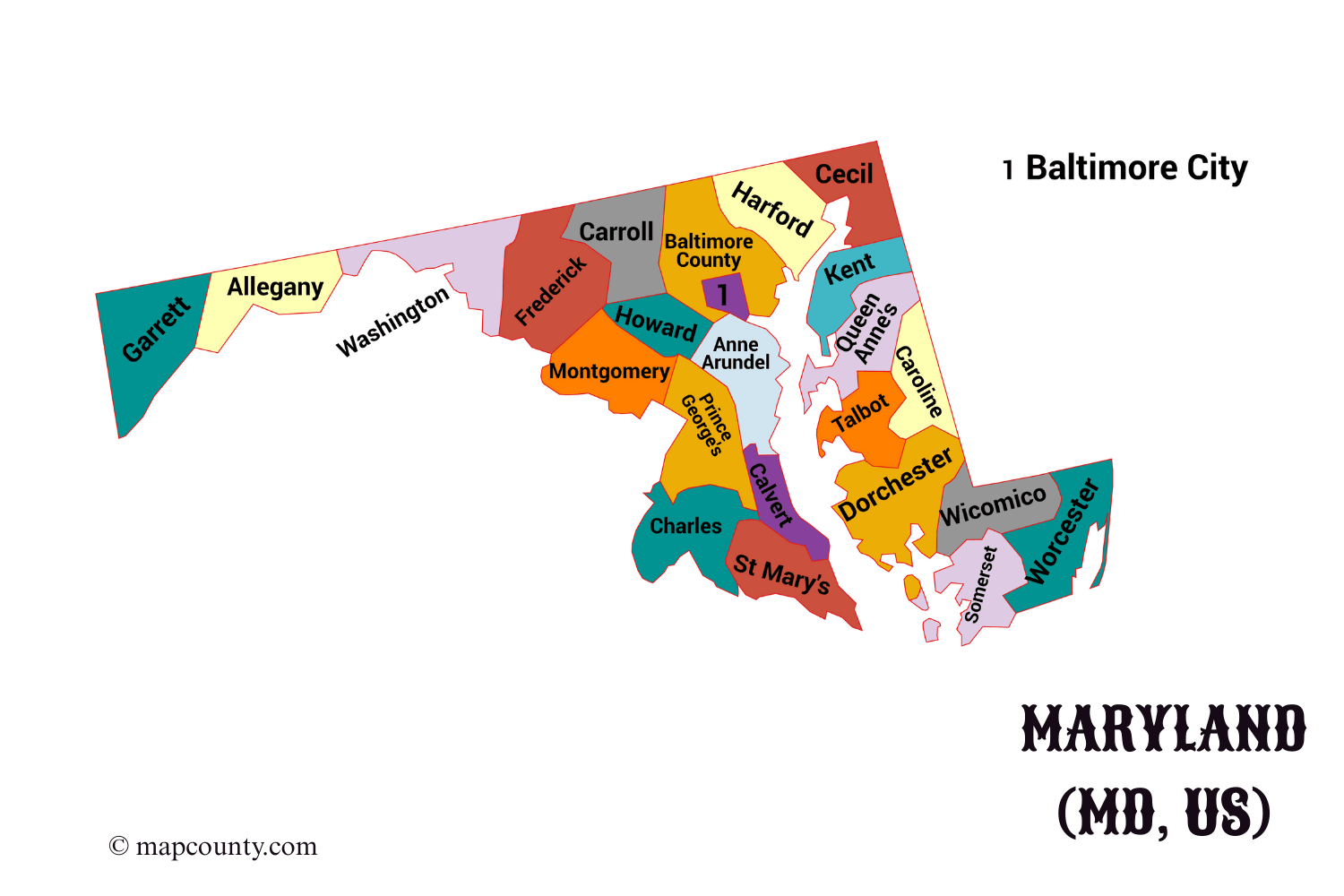
Maryland contains 24 county-level geographic units: 23 counties and Baltimore City. Baltimore City is independent from Baltimore County and has its own five-digit Census GEOID. The table lists every unit with its county seat or independent-city status, Census GEOID, 2025 land area, July 1, 2025 population estimate, and selected incorporated places.
Maryland Counties, County Seats, GEOIDs, Land Area, and Population
| County or Equivalent | County Seat | FIPS / GEOID | Land Area | July 1, 2025 Population Estimate | Major Incorporated Places |
|---|---|---|---|---|---|
| Allegany County | Cumberland | 24001 | 422.2 sq mi | 66,848 | Cumberland, Frostburg, Lonaconing |
| Anne Arundel County | Annapolis | 24003 | 414.8 sq mi | 603,380 | Annapolis, Highland Beach |
| Baltimore County | Towson | 24005 | 598.4 sq mi | 847,650 | No incorporated municipalities; Towson, Dundalk, Catonsville, and Essex are census-designated communities |
| Calvert County | Prince Frederick | 24009 | 213.2 sq mi | 94,484 | Chesapeake Beach, North Beach |
| Caroline County | Denton | 24011 | 319.4 sq mi | 34,116 | Denton, Federalsburg, Greensboro, Ridgely, Preston |
| Carroll County | Westminster | 24013 | 447.6 sq mi | 176,677 | Westminster, Hampstead, Manchester, Mount Airy, Sykesville, Taneytown |
| Cecil County | Elkton | 24015 | 346.3 sq mi | 107,131 | Elkton, North East, Perryville, Rising Sun, Chesapeake City |
| Charles County | La Plata | 24017 | 457.8 sq mi | 176,593 | La Plata, Indian Head, Port Tobacco Village |
| Dorchester County | Cambridge | 24019 | 540.8 sq mi | 33,628 | Cambridge, Hurlock, Vienna, East New Market |
| Frederick County | Frederick | 24021 | 660.6 sq mi | 302,883 | Frederick, Brunswick, Thurmont, Middletown, Walkersville |
| Garrett County | Oakland | 24023 | 649.1 sq mi | 28,370 | Oakland, Mountain Lake Park, Grantsville, Friendsville |
| Harford County | Bel Air | 24025 | 437.1 sq mi | 266,446 | Aberdeen, Bel Air, Havre de Grace |
| Howard County | Ellicott City | 24027 | 251.0 sq mi | 339,183 | No incorporated municipalities; Columbia, Ellicott City, and Savage are census-designated communities |
| Kent County | Chestertown | 24029 | 276.9 sq mi | 19,565 | Chestertown, Rock Hall, Galena, Betterton |
| Montgomery County | Rockville | 24031 | 493.1 sq mi | 1,074,582 | Rockville, Gaithersburg, Takoma Park, Poolesville, Kensington |
| Prince George’s County | Upper Marlboro | 24033 | 482.6 sq mi | 970,374 | Bowie, College Park, Greenbelt, Hyattsville, Laurel |
| Queen Anne’s County | Centreville | 24035 | 371.7 sq mi | 54,448 | Centreville, Queenstown, Church Hill, Sudlersville |
| St. Mary’s County | Leonardtown | 24037 | 358.6 sq mi | 116,692 | Leonardtown |
| Somerset County | Princess Anne | 24039 | 319.7 sq mi | 24,973 | Princess Anne, Crisfield |
| Talbot County | Easton | 24041 | 268.6 sq mi | 38,238 | Easton, St. Michaels, Oxford, Trappe |
| Washington County | Hagerstown | 24043 | 457.8 sq mi | 157,731 | Hagerstown, Boonsboro, Hancock, Smithsburg, Williamsport |
| Wicomico County | Salisbury | 24045 | 374.4 sq mi | 106,899 | Salisbury, Fruitland, Delmar, Hebron, Pittsville |
| Worcester County | Snow Hill | 24047 | 468.3 sq mi | 54,459 | Snow Hill, Berlin, Ocean City, Pocomoke City |
| Baltimore City | Not applicable—independent city | 24510 | 80.9 sq mi | 569,997 | Baltimore |
About Maryland
Maryland is located in the Mid-Atlantic region of the United States. It borders Pennsylvania, Delaware, Virginia, West Virginia, Washington, D.C., and the Atlantic Ocean. The state’s county geography extends from the Appalachian region in the west to the Chesapeake Bay and Atlantic coastal plain in the east.
Geography and Natural Features
Western Maryland contains the state’s highest elevations and includes Allegany and Garrett counties. Central Maryland contains the Baltimore and Washington metropolitan areas. The Eastern Shore lies east of the Chesapeake Bay and includes Caroline, Cecil, Dorchester, Kent, Queen Anne’s, Somerset, Talbot, Wicomico, and Worcester counties.
The Chesapeake Bay divides much of the state into western-shore and Eastern Shore sections. Coastal and bay-facing counties can have total-area measurements much larger than their land-area measurements because water is counted separately. The table therefore reports land area only.
Population Distribution
Maryland’s largest county population in the July 1, 2025 estimates is Montgomery County, followed by Prince George’s County and Baltimore County. Baltimore City remains a separate county equivalent and should not be combined with Baltimore County in county-level datasets.
Population is concentrated in the central part of the state near Washington, D.C., Baltimore, and the Interstate 95 corridor. Several Eastern Shore and western counties have smaller populations spread across towns, rural communities, agricultural land, forests, and coastal areas.
Economy and Industry
Maryland’s economy includes health care, education, biotechnology, federal contracting, defense, port activity, agriculture, fishing, manufacturing, and tourism. Economic patterns vary by county. Central counties have larger employment centers, while the Eastern Shore supports agriculture, seafood production, maritime activity, and seasonal tourism.
County Seats and Municipalities
A county seat is the location where county government is centered. It may not be the county’s largest population center. Upper Marlboro, for example, is the seat of Prince George’s County, while Bowie is one of the county’s larger incorporated cities.
Incorporated municipalities and census-designated communities are different geographic categories. Baltimore County and Howard County have no incorporated municipalities, although both contain large communities identified by the Census Bureau as census-designated places.
Data Sources
- Maryland State Archives: Maryland County Seats
- Maryland State Archives: Municipalities by County
- U.S. Census Bureau: 2025 Maryland County Gazetteer File
- U.S. Census Bureau: County Population Estimates, 2020–2025
- U.S. Census Bureau: Maryland Vintage 2025 County Population Table
- U.S. Census Bureau: Maryland County and County-Equivalent Geography
Frequently Asked Questions
How many counties does Maryland have?
Maryland has 23 counties. Baltimore City is an independent city treated as a county equivalent, producing 24 county-level units in Census data.
Is Baltimore City part of Baltimore County?
No. Baltimore City and Baltimore County are separate geographic and governmental units. Baltimore City has GEOID 24510, while Baltimore County has GEOID 24005.
What is Maryland’s most populous county?
Montgomery County is the most populous county in the July 1, 2025 Census estimates, with an estimated population of 1,074,582.
Which Maryland county contains Annapolis?
Annapolis is in Anne Arundel County. It is both the Maryland state capital and the county seat.
Why are some well-known Maryland communities not listed as incorporated places?
Communities such as Towson, Columbia, Ellicott City, Dundalk, and Catonsville are not incorporated municipalities. The Census Bureau identifies them as census-designated places.
More USA County Maps
- South Dakota County Map with Cities and Towns [SD, US]
- South Carolina County Map with Cities and Towns [SC, US]
- North Carolina County Map with Cities and Towns [NC, US]
- North Dakota County Map with Cities and Towns [ND, US]
- Wyoming County Map with Cities and Towns [WY, US]
- Wisconsin County Map with Cities and Towns [WI, US]