Connecticut County Map: 9 Current Planning Regions and 8 Historic Counties [CT, US]
Connecticut has two county-level map systems that serve different purposes. The U.S. Census Bureau now uses nine planning regions as county-equivalent geographic units for current data collection, tabulation, mapping, and publication. The familiar eight-county map is historical: county governments ended in 1960, and those boundaries were replaced in current Census geography after the 2022 change. Historic counties remain useful for older records, genealogy, cultural references, and legacy maps, but current ACS, population-estimate, and federal county-level work should normally use the nine planning regions.
Connecticut County Map
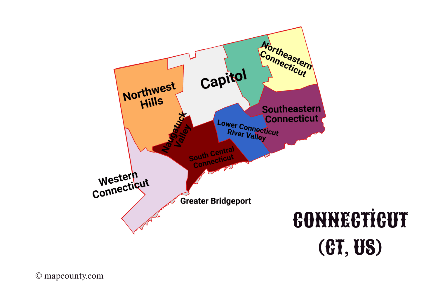
Current Census County Equivalents: Connecticut’s 9 Planning Regions
The Census Bureau adopted Connecticut’s nine Councils of Governments and planning regions as county-equivalent units in 2022. The final federal notice was published on June 6, 2022, and the geographic update was completed during that year. These regions are made from whole cities and towns and are the current county-level geography in Census products.
The change did not create nine conventional county governments. Each council of governments is a regional body formed by member municipalities. The regions are used for Census geography, regional coordination, planning, transportation, shared services, and access to programs that refer to counties or county equivalents.
Legacy view: 8 historic counties
Current GEOIDs: 09110–09190
Municipal coverage: 169 towns
| Current Planning Region | GEOID | Council of Governments | Municipalities | Selected Cities and Towns | Region Center |
|---|---|---|---|---|---|
| Capitol Planning Region | 09110 | Capitol Region Council of Governments | 38 | Hartford, New Britain, Manchester, Tolland | 41.8185, -72.5722 |
| Greater Bridgeport Planning Region | 09120 | Connecticut Metropolitan Council of Governments | 6 | Bridgeport, Fairfield, Stratford, Trumbull | 41.1850, -73.2085 |
| Lower Connecticut River Valley Planning Region | 09130 | Lower Connecticut River Valley Council of Governments | 17 | Middletown, Clinton, Old Saybrook, East Hampton | 41.4206, -72.4920 |
| Naugatuck Valley Planning Region | 09140 | Naugatuck Valley Council of Governments | 19 | Waterbury, Bristol, Naugatuck, Shelton | 41.5230, -73.0861 |
| Northeastern Connecticut Planning Region | 09150 | Northeastern Connecticut Council of Governments | 16 | Putnam, Killingly, Plainfield, Woodstock | 41.8268, -71.9768 |
| Northwest Hills Planning Region | 09160 | Northwest Hills Council of Governments | 21 | Torrington, Litchfield, Winchester, Salisbury | 41.8468, -73.2213 |
| South Central Connecticut Planning Region | 09170 | South Central Regional Council of Governments | 15 | New Haven, Milford, Meriden, Wallingford | 41.2944, -72.8337 |
| Southeastern Connecticut Planning Region | 09180 | Southeastern Connecticut Council of Governments | 19 | New London, Norwich, Groton, Windham | 41.4847, -72.1006 |
| Western Connecticut Planning Region | 09190 | Western Connecticut Council of Governments | 18 | Stamford, Danbury, Norwalk, Greenwich | 41.2805, -73.4472 |
Historic Connecticut Counties
Connecticut’s eight county names remain common in historical records, local identity, genealogy, older maps, and legacy datasets. Their former county GEOIDs identify the historical geography and should not be substituted for the current planning-region codes.
| Historic County | Legacy GEOID | Established | General Area | Current Status |
|---|---|---|---|---|
| Fairfield County | 09001 | 1666 | Southwestern Connecticut and the western Long Island Sound coast | Historic geography; split among three current planning regions |
| Hartford County | 09003 | 1666 | North-central Connecticut and the Hartford area | Historic geography; split among three current planning regions |
| Litchfield County | 09005 | 1751 | Northwestern Connecticut | Historic geography; split among three current planning regions |
| Middlesex County | 09007 | 1785 | Central Connecticut River communities and the central coast | Historic geography; its towns map to one current planning region |
| New Haven County | 09009 | 1666 | South-central Connecticut | Historic geography; split between two current planning regions |
| New London County | 09011 | 1666 | Southeastern Connecticut | Historic geography; split among three current planning regions |
| Tolland County | 09013 | 1785 | North-central and northeastern interior Connecticut | Historic geography; split between two current planning regions |
| Windham County | 09015 | 1726 | Northeastern Connecticut | Historic geography; split between two current planning regions |
Historic County to Planning Region Crosswalk
The crosswalk follows Connecticut’s 169 towns from their former county parent to their current county-equivalent planning region. The numbers in parentheses are town counts. A historic county total cannot be converted by changing its label because several former counties are divided across multiple planning regions.
| Historic County | Current Planning Region Allocation | Boundary Split Notes |
|---|---|---|
| Fairfield County | Greater Bridgeport (6); Naugatuck Valley (1); Western Connecticut (16) | Shelton moved to the Naugatuck Valley geography; most western and southwestern towns are in Western Connecticut. |
| Hartford County | Capitol (26); Naugatuck Valley (1); Northwest Hills (2) | Bristol is in Naugatuck Valley; Burlington and Hartland are in Northwest Hills. |
| Litchfield County | Naugatuck Valley (5); Northwest Hills (19); Western Connecticut (2) | Bridgewater and New Milford are in Western Connecticut; five southeastern Litchfield towns are in Naugatuck Valley. |
| Middlesex County | Lower Connecticut River Valley (15) | All 15 historic Middlesex County towns are in the same current planning region. |
| New Haven County | Naugatuck Valley (12); South Central Connecticut (15) | The former county is divided between the inland Naugatuck Valley and the south-central coastal and New Haven area. |
| New London County | Lower Connecticut River Valley (2); Northeastern Connecticut (1); Southeastern Connecticut (18) | Lyme and Old Lyme are in Lower Connecticut River Valley; Voluntown is in Northeastern Connecticut. |
| Tolland County | Capitol (12); Northeastern Connecticut (1) | Union is in Northeastern Connecticut; the other 12 historic Tolland County towns are in the Capitol region. |
| Windham County | Northeastern Connecticut (14); Southeastern Connecticut (1) | Windham town is in Southeastern Connecticut; the other 14 towns are in Northeastern Connecticut. |
Major Cities and Their Current Planning Regions
City references should identify the current planning region when the purpose is Census, demographic, economic, or federal county-level analysis. The historic county remains useful when the source record or map uses the older boundary system.
| City | Historic County | Current Planning Region | Latitude | Longitude | Map Role |
|---|---|---|---|---|---|
| Bridgeport | Fairfield County | Greater Bridgeport Planning Region | 41.1792 | -73.1894 | Regional center on Long Island Sound |
| New Haven | New Haven County | South Central Connecticut Planning Region | 41.3083 | -72.9279 | South-central urban center |
| Stamford | Fairfield County | Western Connecticut Planning Region | 41.0534 | -73.5387 | Southwestern coastal center |
| Hartford | Hartford County | Capitol Planning Region | 41.7658 | -72.6734 | State capital |
| Waterbury | New Haven County | Naugatuck Valley Planning Region | 41.5582 | -73.0515 | Inland Naugatuck Valley center |
| Norwalk | Fairfield County | Western Connecticut Planning Region | 41.1177 | -73.4082 | Southwestern coastal city |
| Danbury | Fairfield County | Western Connecticut Planning Region | 41.3948 | -73.4540 | Western inland center |
| New Britain | Hartford County | Capitol Planning Region | 41.6612 | -72.7795 | Central urban center |
| Bristol | Hartford County | Naugatuck Valley Planning Region | 41.6718 | -72.9493 | Crosswalk example between old and current geography |
| Meriden | New Haven County | South Central Connecticut Planning Region | 41.5382 | -72.8070 | Central corridor city |
Data Transition and Boundary Use
Map Data Notes
- Current boundary source: Census Bureau county-equivalent planning-region geography and Connecticut Office of Policy and Management municipality assignments.
- Historic boundary source: The eight former counties and their legacy GEOIDs, retained for older geographic reference.
- Coordinates: Planning-region centers use Census TIGER geographic center values. City coordinates are approximate center points, not street addresses.
- Municipality counts: Counts cover all 169 Connecticut towns and assign each town to one current planning region.
- Best map use: Use the official planning-region map for current boundaries and the MapCounty image for the historical eight-county view.
Official Maps and Sources
- U.S. Census Bureau: Connecticut Planning Regions Reference Map
- U.S. Census Bureau: Final Change to County Equivalents in Connecticut
- U.S. Census Bureau: 2022 ACS County-Equivalent User Note
- U.S. Census Bureau: Connecticut Former County to Town and Planning Region Crosswalk
- U.S. Census TIGERweb: Current Connecticut County-Equivalent GEOIDs and Centers
- Connecticut Office of Policy and Management: Planning Regions Overview
- Connecticut OPM: Municipality, Planning Region, and COG List
Frequently Asked Questions
How many counties does Connecticut have?
Connecticut has eight historic counties. Current Census county-level geography uses nine planning regions as county equivalents.
Does Connecticut still have county governments?
No. County governments ended in 1960. Cities, towns, state agencies, and regional councils of governments perform the public and regional functions used in the state today.
When did the Census Bureau replace the eight counties?
The Census Bureau adopted the nine planning regions as county equivalents in 2022. Current geospatial and statistical products began moving to the new geography through the 2022 data cycle.
Are historic county names still useful?
Yes. They remain useful for historical research, genealogy, older records, local identity, and legacy maps. They are not the default county-equivalent units for current Census reporting.
Can old county data be renamed as planning-region data?
No. The boundaries differ, and several historic counties are divided among two or three planning regions. Town-level crosswalks or re-tabulated data are needed.
Why do some recent datasets still show the old counties?
Some products preserve earlier geographic definitions or combine county geography with metropolitan areas built from an older vintage. The release notes and GEOIDs identify which boundary system is being used.
More USA County Maps
- South Dakota County Map with Cities and Towns [SD, US]
- South Carolina County Map with Cities and Towns [SC, US]
- North Carolina County Map with Cities and Towns [NC, US]
- North Dakota County Map with Cities and Towns [ND, US]
- Wyoming County Map with Cities and Towns [WY, US]
- Wisconsin County Map with Cities and Towns [WI, US]