Alabama, located in the Southeastern United States, is composed of 67 counties. Admitted to the Union as the 22nd state in 1819, Alabama is known for its rich history, diverse landscapes, and vibrant cities. This guide provides a detailed overview of Alabama’s county and city structure.
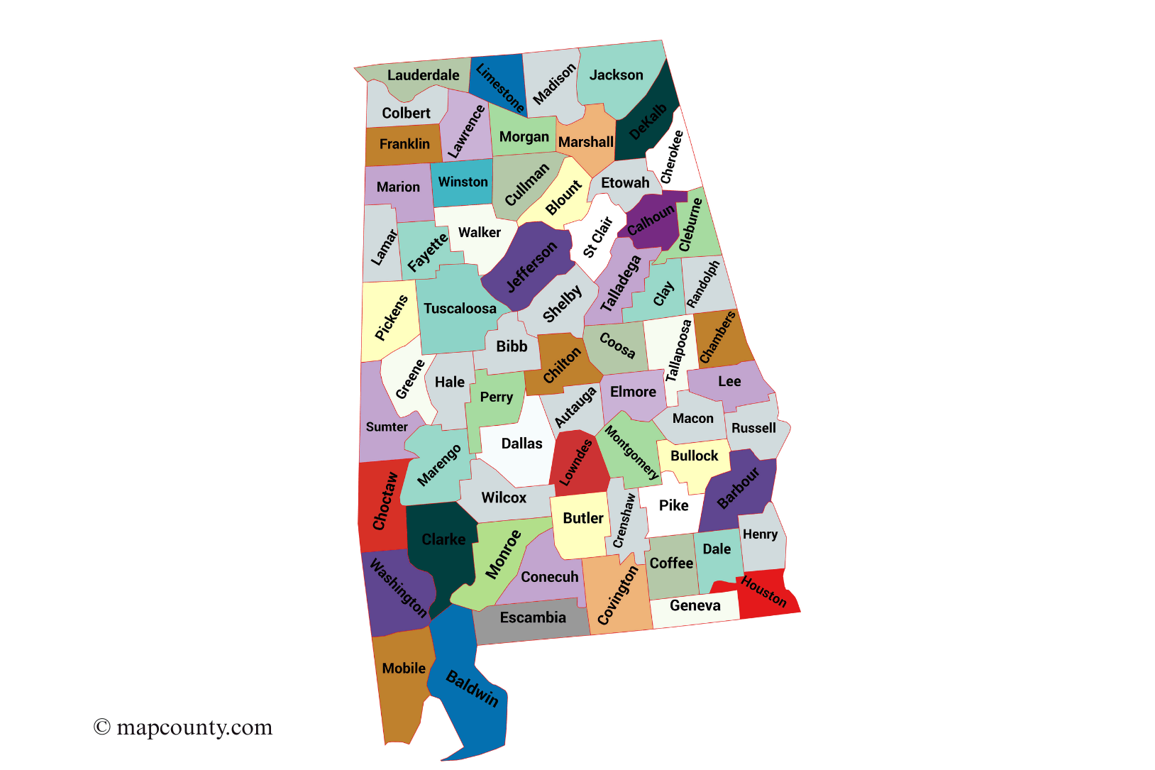
✅Alabama County Map
The map below shows the geographical distribution of Alabama’s 67 counties:
PDF : Alabama County Map PDF
✅Alabama Counties with County Seats, Founded Dates, and Areas
| County | County Seat | Founded | Area (sq mi) | Notes / Major Cities |
|---|---|---|---|---|
| Autauga County | Prattville | 1818 | 604 | Part of Montgomery metro area |
| Baldwin County | Bay Minette | 1809 | 1,590 | Gulf Coast; beaches, Mobile suburbs |
| Barbour County | Clayton | 1832 | 905 | Rural county, historic towns |
| Bibb County | Centreville | 1818 | 626 | Forested areas, small population |
| Blount County | Oneonta | 1818 | 651 | Scenic mountains, waterfalls |
| Bullock County | Union Springs | 1866 | 625 | Agricultural region |
| Butler County | Greenville | 1819 | 778 | Agriculture and small towns |
| Calhoun County | Anniston | 1832 | 612 | Industrial history |
| Chambers County | LaFayette | 1832 | 666 | Border county with Georgia |
| Cherokee County | Centre | 1836 | 600 | Appalachian foothills |
| Chilton County | Clanton | 1868 | 703 | Peach farming region |
| Choctaw County | Butler | 1847 | 921 | Forests, rural economy |
| Clarke County | Grove Hill | 1812 | 1,253 | Historic towns, timber industry |
| Clay County | Ashland | 1866 | 606 | Small population, rural |
| Cleburne County | Heflin | 1866 | 561 | Border county with Georgia |
| Colbert County | Tuscumbia | 1867 | 622 | Muscle Shoals, Tennessee River |
| Conecuh County | Evergreen | 1818 | 852 | Rural, agriculture |
| Coosa County | Rockford | 1832 | 666 | Forested, small towns |
| Covington County | Andalusia | 1821 | 1,044 | Southern Alabama, agriculture |
| Crenshaw County | Luverne | 1866 | 611 | Rural, agriculture |
| Cullman County | Cullman | 1877 | 755 | German heritage, agriculture |
| Dale County | Ozark | 1824 | 563 | Fort Rucker nearby |
| Dallas County | Selma | 1817 | 994 | Civil Rights landmarks |
| DeKalb County | Fort Payne | 1836 | 760 | Mountains, waterfalls |
| Elmore County | Wetumpka | 1866 | 657 | Suburban growth, lakes |
| Escambia County | Brewton | 1868 | 953 | Coastal plains, timber |
| Etowah County | Gadsden | 1866 | 549 | Industrial history, rivers |
| Fayette County | Fayette | 1824 | 629 | Rural, agriculture |
| Franklin County | Russellville | 1818 | 647 | Northwest Alabama, small towns |
| Geneva County | Geneva | 1868 | 579 | Southern agriculture, border with Florida |
| Greene County | Eutaw | 1819 | 660 | Historic plantations |
| Hale County | Greensboro | 1867 | 657 | Rural, Civil Rights history |
| Henry County | Abbeville | 1819 | 568 | Southern Alabama, agriculture |
| Houston County | Dothan | 1903 | 582 | Largest city: Dothan; peanut farming |
| Jackson County | Scottsboro | 1819 | 1,127 | Northeast mountains, Tennessee border |
| Jefferson County | Birmingham | 1819 | 1,121 | Largest population; industrial hub |
| Lamar County | Vernon | 1867 | 605 | Small towns, rural |
| Lauderdale County | Florence | 1818 | 721 | Florence-Muscle Shoals area |
| Lawrence County | Moulton | 1818 | 718 | Muscle Shoals outskirts, rural |
| Lee County | Auburn | 1866 | 616 | Auburn University; suburban growth |
| Limestone County | Athens | 1818 | 607 | Huntsville metro suburbs |
| Lowndes County | Hayneville | 1830 | 725 | Rural, civil rights history |
| Macon County | Montevallo | 1832 | 613 | University of Alabama at Tuskegee nearby |
| Madison County | Huntsville | 1808 | 813 | NASA and tech industry hub |
| Marengo County | Linden | 1818 | 983 | Historic plantations |
| Marion County | Hamilton | 1818 | 742 | Northwest Alabama, rural |
| Marshall County | Guntersville | 1836 | 623 | Lakes, mountains |
| Mobile County | Mobile | 1812 | 1,644 | Port city, Gulf Coast |
| Monroe County | Monroeville | 1815 | 1,034 | Harper Lee’s hometown; rural |
| Montgomery County | Montgomery | 1816 | 800 | State capital; historical landmarks |
| Morgan County | Decatur | 1818 | 599 | Decatur-Hartselle metro area |
| Perry County | Marion | 1819 | 724 | Rural, agricultural |
| Pickens County | Carrollton | 1820 | 890 | Alabama River region |
| Platte County | Wilsonville | 1818 | 791 | Rural, small towns |
| Pike County | Troy | 1821 | 673 | Home to Troy University |
| Randolph County | Wedowee | 1832 | 584 | East central Alabama, rural |
| Russell County | Phenix City | 1832 | 647 | Columbus metro suburbs |
| St. Clair County | Ashville | 1818 | 654 | Growing suburban area |
| Shelby County | Columbiana | 1818 | 810 | Rapid suburban growth |
| Sumter County | Livingston | 1832 | 913 | University of West Alabama |
| Talladega County | Talladega | 1832 | 617 | Motor Speedway; historic towns |
| Tallapoosa County | Alexander City | 1832 | 766 | Lake Martin, rural towns |
| Texar County | Winfield | 1850 | 579 | Northwest Alabama, rural |
| Tipton County | Tipton | 1822 | 407 | Small towns, agriculture |
| Tuscaloosa County | Tuscaloosa | 1818 | 1,195 | University of Alabama; riverfront city |
| Walker County | Jasper | 1823 | 805 | Coal mining region |
| Washington County | Chatom | 1800 | 1,089 | Gulf Coast, rural |
| Wilcox County | Camden | 1819 | 907 | Agriculture, small towns |
| Winston County | Double Springs | 1850 | 637 | Mountains, historic voting traditions |
Major Cities in Alabama
- Birmingham: County: Jefferson. Largest city; industrial and cultural center.
- Montgomery: County: Montgomery. State capital; historic Civil Rights landmarks.
- Mobile: County: Mobile. Gulf Coast port city; historic architecture.
- Huntsville: County: Madison. NASA and aerospace industry hub.
- Tuscaloosa: County: Tuscaloosa. University of Alabama; sports and cultural events.
Geographical and Cultural Diversity
Alabama’s counties feature a variety of geographical landscapes, from the Appalachian Mountains in the north to the Gulf Coast beaches in the south. The state has a rich history, from Native American heritage to important events in the Civil Rights Movement.
The variation in population density across counties reflects both the state’s urban centers and its vast rural areas, with Jefferson County being the most populous region in the state.
More USA County Maps
- South Dakota County Map with Cities and Towns [SD, US]
- South Carolina County Map with Cities and Towns [SC, US]
- North Carolina County Map with Cities and Towns [NC, US]
- North Dakota County Map with Cities and Towns [ND, US]
- Wyoming County Map with Cities and Towns [WY, US]
- Wisconsin County Map with Cities and Towns [WI, US]