Arizona is divided into 15 counties, and each county plays a clear role on the state map. The main city pattern is easy to follow: Phoenix and many large suburbs sit in Maricopa County, Tucson anchors Pima County, and smaller regional cities serve the northern, western, central, and southeastern parts of the state. This Arizona county map guide focuses first on cities, towns, county seats, area, and county layout in simple, useful detail.
Quick Orientation: Arizona uses counties as the main county-level division. A county seat is the administrative center of a county. Some counties contain large cities, while others cover wide rural or mountain areas with smaller towns and communities.
Arizona County Map With Cities and Towns AZ, US
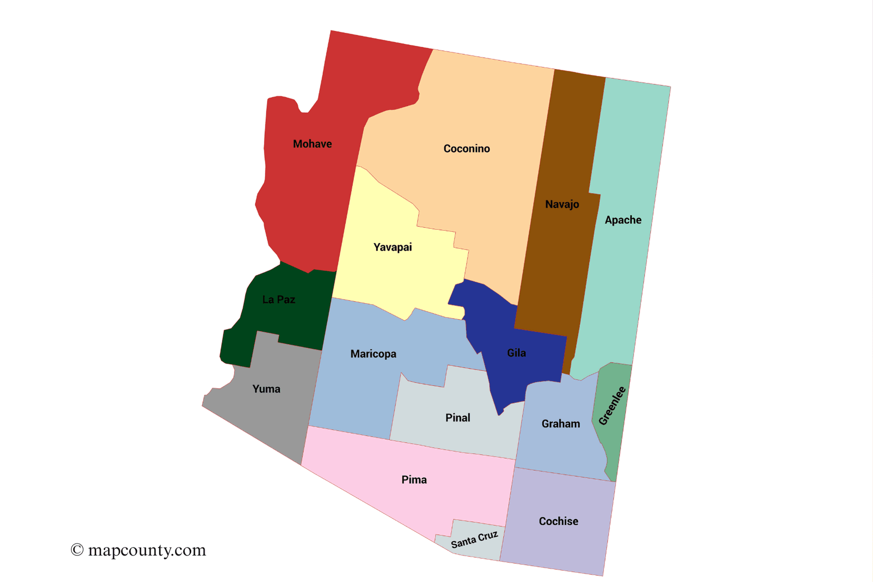
The Arizona county map below shows how the state is divided from the Colorado Plateau in the north to the Sonoran Desert and southern valleys. It is most useful for locating county boundaries, major cities, county seats, and regional travel patterns.
Arizona County Quick Facts
Counties
Total county-level divisions in Arizona
State Capital
Also the county seat of Maricopa County
Largest County By Area
About 18,661 square miles
Smallest County By Area
About 1,238 square miles
Most Populated County
Home to Phoenix, Mesa, Chandler, Glendale, Scottsdale, and more
Approx. Land Area
Square miles of land across Arizona
All Arizona Counties With County Seats, Cities, Areas and Population
The table below lists every county in Arizona. It includes the county seat, founding year, area, 2020 census population, and important cities or towns to recognize on a county map.
| County | County Seat | Founded | Area Sq Mi | 2020 Population | Major Cities, Towns and Map Notes |
|---|---|---|---|---|---|
| Apache County | St. Johns | 1879 | 11,218 | 66,021 | St. Johns, Chinle, Eagar, Springerville, Window Rock area; large northeastern county with many high-country communities. |
| Cochise County | Bisbee | 1881 | 6,219 | 125,447 | Sierra Vista, Bisbee, Douglas, Benson, Willcox; important southeastern Arizona county with several historic towns. |
| Coconino County | Flagstaff | 1891 | 18,661 | 145,101 | Flagstaff, Page, Williams, Tusayan; largest Arizona county by area and a key northern Arizona region. |
| Gila County | Globe | 1881 | 4,796 | 53,272 | Globe, Payson, Miami; central Arizona county with mountain towns and forest-edge communities. |
| Graham County | Safford | 1881 | 4,641 | 38,533 | Safford, Thatcher, Pima; southeastern interior county centered on valley communities. |
| Greenlee County | Clifton | 1909 | 1,848 | 9,563 | Clifton, Duncan; small eastern Arizona county by population with compact town centers. |
| La Paz County | Parker | 1983 | 4,513 | 16,557 | Parker, Quartzsite, Salome; western Arizona county along the lower Colorado River corridor. |
| Maricopa County | Phoenix | 1871 | 9,224 | 4,420,568 | Phoenix, Mesa, Chandler, Glendale, Scottsdale, Gilbert, Tempe, Peoria, Surprise; main population center of Arizona. |
| Mohave County | Kingman | 1864 | 13,470 | 213,267 | Kingman, Lake Havasu City, Bullhead City; large northwestern county with highway, river, and lake communities. |
| Navajo County | Holbrook | 1895 | 9,959 | 106,717 | Holbrook, Show Low, Winslow, Snowflake, Pinetop-Lakeside; northeastern county with plateau and mountain towns. |
| Pima County | Tucson | 1864 | 9,189 | 1,043,433 | Tucson, Oro Valley, Marana, Sahuarita, South Tucson; second major population center in Arizona. |
| Pinal County | Florence | 1875 | 5,374 | 425,264 | Florence, Casa Grande, Maricopa, Apache Junction, Coolidge, Eloy; central growth corridor between Phoenix and Tucson. |
| Santa Cruz County | Nogales | 1899 | 1,238 | 47,669 | Nogales, Patagonia, Rio Rico, Tubac area; smallest Arizona county by area. |
| Yavapai County | Prescott | 1864 | 8,128 | 236,209 | Prescott, Prescott Valley, Cottonwood, Camp Verde, Chino Valley, Sedona area; central highlands county. |
| Yuma County | Yuma | 1864 | 5,519 | 203,881 | Yuma, San Luis, Somerton, Wellton; southwestern county with strong agricultural and river-valley communities. |
How To Read The Arizona County Map
An Arizona county map becomes easier to understand when you read it in layers. Start with the county shape, then look for the county seat, then connect nearby cities and towns.
- Find the county boundary. Arizona counties vary widely in size. Coconino, Mohave, Apache, Navajo, and Maricopa cover especially large areas.
- Locate the county seat. The county seat is the administrative center. Phoenix, Tucson, Flagstaff, Prescott, Kingman, Yuma, and Globe are examples.
- Check the city cluster. Some counties have many cities close together. Maricopa County is the clearest example.
- Notice regional distance. Northern and western counties can look close on a state map, but the actual driving distance may be long because the counties are large.
Helpful Map Tip: When looking for a city in Arizona, first identify its county. This is especially useful for places near metro boundaries, such as Peoria, Queen Creek, Apache Junction, Sedona, and Marana, where local areas may connect across county lines or sit near a county edge.
Major Cities and Towns On An Arizona County Map
Arizona has one very large urban core around Phoenix, a second major city region around Tucson, and several regional centers spread across the state. The cities below are among the most useful places to recognize when reading an Arizona county map with cities and towns.
| City or Town | County | Map Role | Simple Location Note |
|---|---|---|---|
| Phoenix | Maricopa | State Capital | Main city of Arizona and the center of the Phoenix metro area. |
| Tucson | Pima | Major City | Main city of southern Arizona and the center of Pima County. |
| Mesa | Maricopa | Large Suburban City | East of Phoenix and part of the East Valley. |
| Chandler | Maricopa | East Valley City | Southeast of Phoenix, near Gilbert and Tempe. |
| Gilbert | Maricopa | East Valley Town | Large incorporated town southeast of Phoenix. |
| Glendale | Maricopa | West Valley City | Northwest of central Phoenix. |
| Scottsdale | Maricopa | Metro City | East and northeast of Phoenix. |
| Peoria | Maricopa and Yavapai | Multi-County City | Mostly in Maricopa County, with northern portions reaching Yavapai County. |
| Tempe | Maricopa | Central Metro City | Between Phoenix, Mesa, Chandler, and Scottsdale. |
| Surprise | Maricopa | West Valley City | Northwest part of the Phoenix metro area. |
| Yuma | Yuma | Regional Center | Main city of southwestern Arizona. |
| Avondale | Maricopa | West Valley City | West of Phoenix near Goodyear and Tolleson. |
| Goodyear | Maricopa | West Valley City | West of Phoenix and part of the growing metro edge. |
| Flagstaff | Coconino | County Seat | Main city of northern Arizona and county seat of Coconino County. |
| Buckeye | Maricopa | Western Metro City | Far western part of the Phoenix metro area. |
| Casa Grande | Pinal | Central Corridor City | Between Phoenix and Tucson in Pinal County. |
| Prescott | Yavapai | County Seat | Central highlands city and county seat of Yavapai County. |
| Sierra Vista | Cochise | Regional City | Major city in southeastern Arizona. |
| Lake Havasu City | Mohave | Western City | Important city in western Arizona near the Colorado River area. |
| Kingman | Mohave | County Seat | County seat of Mohave County and a key northwestern Arizona road hub. |
Arizona City Pattern By County
The state map makes more sense when the main cities are grouped by county. Arizona does not spread its largest cities evenly across every county. Instead, population is heavily concentrated in a few counties, while large rural and mountain counties use smaller towns as local service centers.
Maricopa County Cities
Phoenix, Mesa, Chandler, Glendale, Scottsdale, Gilbert, Tempe, Peoria, Surprise, Avondale, Goodyear, Buckeye
This is the main urban county in Arizona and the easiest place to see dense city clustering on the map.
Pima County Cities
Tucson, Oro Valley, Marana, Sahuarita, South Tucson
Pima County forms the second major city region in the state, centered on Tucson.
Pinal County Cities and Towns
Casa Grande, Maricopa, Florence, Coolidge, Apache Junction, Eloy
Pinal County sits between the Phoenix and Tucson areas, which makes it important on regional maps.
Northern Arizona Cities and Towns
Flagstaff, Page, Williams, Holbrook, Winslow, Show Low
Northern Arizona counties are large, so towns may appear far apart even within the same county.
Western Arizona Cities and Towns
Yuma, Parker, Quartzsite, Kingman, Lake Havasu City, Bullhead City
Western counties connect river, desert, highway, and lake communities.
Southeastern Arizona Cities and Towns
Sierra Vista, Bisbee, Douglas, Benson, Willcox, Safford, Thatcher
This region has several mid-sized and small communities that serve wide rural areas.
Arizona Counties By Region
Arizona counties can be read as regional groups. This helps when comparing a county map with a road map, travel route, school district map, business service area, or local government boundary.
| Region | Counties | Main City Pattern |
|---|---|---|
| Central Arizona | Maricopa, Pinal, Gila, Yavapai | Phoenix metro cities dominate Maricopa County, while Pinal links the Phoenix and Tucson corridors. Gila and Yavapai use smaller mountain and highland cities as local centers. |
| Southern Arizona | Pima, Santa Cruz, Cochise | Tucson is the main city anchor. Nogales, Sierra Vista, Bisbee, Douglas, and other towns support southern and southeastern county areas. |
| Northern Arizona | Coconino, Navajo, Apache | Flagstaff is the largest northern city, while Page, Williams, Holbrook, Winslow, Show Low, and St. Johns are important county-map points. |
| Western Arizona | Mohave, La Paz, Yuma | Yuma, Kingman, Lake Havasu City, Bullhead City, Parker, and Quartzsite help define the western county layout. |
| Eastern Arizona | Graham, Greenlee, Apache, Navajo | Safford, Clifton, Duncan, St. Johns, Show Low, and nearby communities help organize the eastern side of the state map. |
County Seats In Arizona
County seats are important because they identify the main administrative location in each county. Some county seats are large cities, such as Phoenix and Tucson. Others are smaller towns that still hold a central county role, such as Florence, Globe, Clifton, and St. Johns.
Map Reading Note: A county seat is not always the largest city in the county. For example, Florence is the county seat of Pinal County, but Casa Grande and Maricopa are often more visible as population centers on a modern city map.
Largest and Smallest Arizona Counties
Arizona has counties with very different sizes. This is why a statewide county map can look uneven. Some counties cover huge open areas, while others are compact but important because of cities and population.
- Largest by area: Coconino County, about 18,661 square miles.
- Second large by area: Mohave County, about 13,470 square miles.
- Largest by population: Maricopa County, with Phoenix and many of the largest Arizona cities.
- Smallest by area: Santa Cruz County, about 1,238 square miles.
- Small county by population: Greenlee County, with Clifton as the county seat.
County Notes For Map Readers
Maricopa County
Maricopa County is the central county for most Arizona city searches. It contains Phoenix and many large suburbs. On a map, it forms the main urban cluster of the state.
Pima County
Pima County is anchored by Tucson. It is the main county to recognize when reading maps of southern Arizona cities and towns.
Pinal County
Pinal County sits between the Phoenix and Tucson regions. Cities and towns such as Casa Grande, Maricopa, Florence, and Apache Junction make it a key connector county.
Coconino County
Coconino County is the largest county by area. Flagstaff, Page, Williams, and Tusayan are important names to look for on northern Arizona maps.
Mohave County
Mohave County covers a large part of northwestern Arizona. Kingman, Lake Havasu City, and Bullhead City are the main city names to identify.
Yavapai County
Yavapai County covers central highland areas. Prescott, Prescott Valley, Cottonwood, Camp Verde, and Sedona area communities are common map references.
Arizona County Map Questions
How Many Counties Are In Arizona?
Arizona has 15 counties. These counties are Apache, Cochise, Coconino, Gila, Graham, Greenlee, La Paz, Maricopa, Mohave, Navajo, Pima, Pinal, Santa Cruz, Yavapai, and Yuma.
Which Arizona County Has Phoenix?
Phoenix is in Maricopa County. Phoenix is also the county seat of Maricopa County and the state capital of Arizona.
Which Arizona County Has Tucson?
Tucson is in Pima County. Tucson is the county seat and main city of Pima County.
What Is The Largest County In Arizona By Area?
Coconino County is the largest county in Arizona by area. It covers about 18,661 square miles.
What Is The Smallest County In Arizona By Area?
Santa Cruz County is the smallest county in Arizona by area. It covers about 1,238 square miles.
Which Arizona County Has The Most Large Cities?
Maricopa County has the largest cluster of major Arizona cities, including Phoenix, Mesa, Chandler, Glendale, Scottsdale, Gilbert, Tempe, Peoria, Surprise, Avondale, Goodyear, and Buckeye.
More USA County Maps
- South Dakota County Map with Cities and Towns [SD, US]
- South Carolina County Map with Cities and Towns [SC, US]
- North Carolina County Map with Cities and Towns [NC, US]
- North Dakota County Map with Cities and Towns [ND, US]
- Wyoming County Map with Cities and Towns [WY, US]
- Wisconsin County Map with Cities and Towns [WI, US]