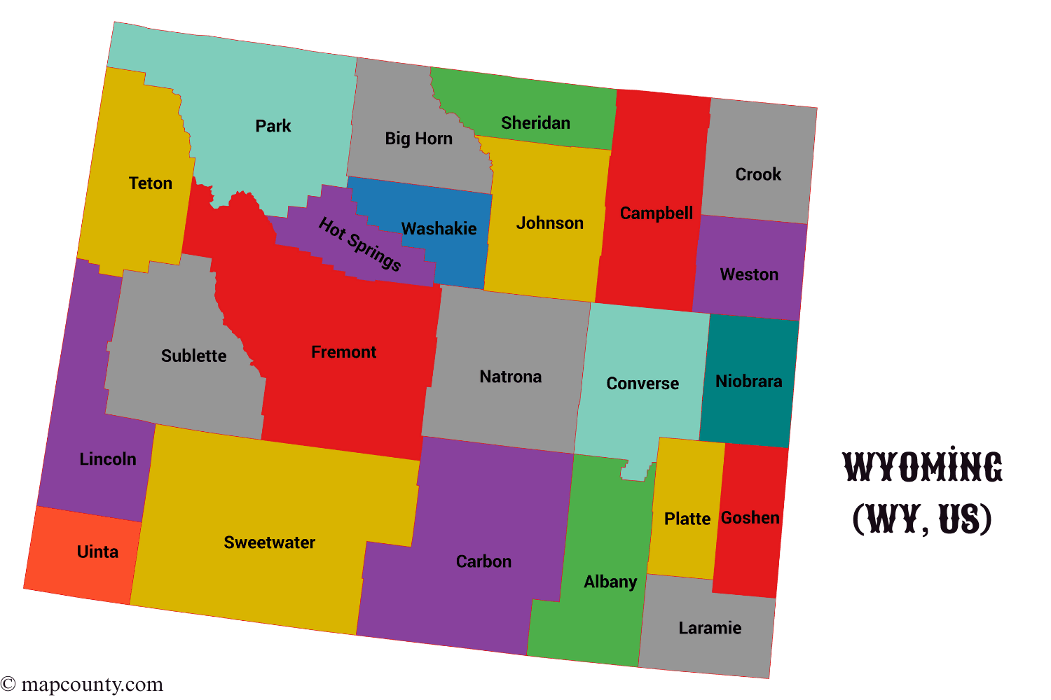
Wyoming Counties and County Seats: Complete List
Wyoming is organized into 23 counties. If you are comparing places, planning services, researching property records, or sorting data by location, counties are the cleanest way to do it. This page keeps the focus on Wyoming county names, county seats, and practical stats you can scan fast.
Quick Snapshot
Largest by Area: Sweetwater County (10,426 sq mi) |
Smallest by Area: Hot Springs County (2,004 sq mi)
Highest Population: Laramie County (101,783) |
Lowest Population: Niobrara County (2,301)
State FIPS Prefix: 56 (county codes shown below as three digits)
| County | County Seat | Established | FIPS | Area (sq mi) | Population |
|---|---|---|---|---|---|
| Albany | Laramie | 1868 | 001 | 4,274 | 39,288 |
| Big Horn | Basin | 1896 | 003 | 3,137 | 12,084 |
| Campbell | Gillette | 1911 | 005 | 4,797 | 47,946 |
| Carbon | Rawlins | 1868 | 007 | 7,897 | 14,250 |
| Converse | Douglas | 1888 | 009 | 4,255 | 13,766 |
| Crook | Sundance | 1875 | 011 | 2,859 | 7,775 |
| Fremont | Lander | 1884 | 013 | 9,183 | 39,721 |
| Goshen | Torrington | 1911 | 015 | 2,225 | 12,635 |
| Hot Springs | Thermopolis | 1911 | 017 | 2,004 | 4,625 |
| Johnson | Buffalo | 1875 | 019 | 4,166 | 8,803 |
| Laramie | Cheyenne | 1867 | 021 | 2,686 | 101,783 |
| Lincoln | Kemmerer | 1911 | 023 | 4,069 | 21,000 |
| Natrona | Casper | 1888 | 025 | 5,340 | 80,410 |
| Niobrara | Lusk | 1911 | 027 | 2,626 | 2,301 |
| Park | Cody | 1909 | 029 | 6,943 | 31,082 |
| Platte | Wheatland | 1911 | 031 | 2,085 | 8,512 |
| Sheridan | Sheridan | 1888 | 033 | 2,523 | 32,978 |
| Sublette | Pinedale | 1921 | 035 | 4,882 | 8,965 |
| Sweetwater | Green River | 1867 | 037 | 10,426 | 41,273 |
| Teton | Jackson | 1921 | 039 | 4,008 | 23,272 |
| Uinta | Evanston | 1869 | 041 | 2,082 | 20,621 |
| Washakie | Worland | 1911 | 043 | 2,240 | 7,662 |
| Weston | Newcastle | 1890 | 045 | 2,398 | 6,866 |
County Basics: What A Wyoming County Usually Manages
Why Counties Matter
A county is a local service area with boundaries that stay stable for a long time. It is helpful for:
- Addresses and locations when a place is outside city limits
- Property and land records tied to parcels and legal descriptions
- Courts and filings organized by jurisdiction
- Road and infrastructure planning across wide rural areas
- Public services that cover towns and open country together
What A County Seat Is
The county seat is the main administrative hub. It is where you typically find the primary county offices, record systems, and central service counters. Seats are also a quick shortcut when you need a starting point for local questions.
Small Tip
If you know the county seat, you can often locate the right county department faster. Many records are accesible through request forms, phone directories, or public counters.
Read A County Table Like A Pro
FIPS is a standardized code used to identify counties in datasets. Wyoming uses state prefix 56. A full county code is usually written as 56 plus the three digit county code.
- Example format: 56021 maps to Laramie County
- Why it helps: it avoids confusion when place names repeat in different states
- Best use: sorting, filtering, and matching records across sources
Area stays stable, so it is great for long term comparisons. Population changes over time, so think of it as a snapshot.
- Use area to understand scale, travel distance, and service coverage.
- Use population to estimate demand for services and typical settlement patterns.
- Use both to spot density differences without any complicated math.
Regional Guide To Wyoming Counties
Wyoming counties cover wide landscapes. Grouping them by region makes the list easier to remember. These groupings are practical, not official.
Northwest Wyoming Counties
Big Horn (Basin) and Washakie (Worland) sit near basins, river systems, and mountain edges.
- Park (Cody): gateway for major parkland and dramatic terrain
- Hot Springs (Thermopolis): smallest county by area in the state
Northeast Wyoming Counties
This corner is known for broad plains and long travel corridors between communities.
- Campbell (Gillette): among the highest population totals in Wyoming
- Crook (Sundance): smaller population, compact footprint
- Weston (Newcastle): southern part of the northeast cluster
North Central Wyoming Counties
Sheridan (Sheridan) and Johnson (Buffalo) form a clean pair for many regional comparisons.
- Sheridan: smaller area, strong service center role in the region
- Johnson: larger land area relative to its population
Central Wyoming Counties
These counties often show up in statewide datasets because they include major transport routes and service hubs.
- Natrona (Casper): one of the largest county populations
- Fremont (Lander): one of the largest counties by land area
- Converse (Douglas): central access point between multiple regions
Southeast Wyoming Counties
This region includes the state capital area and several counties that work well for front range comparisons.
- Laramie (Cheyenne): highest population in Wyoming
- Albany (Laramie): large footprint, key education hub
- Platte (Wheatland): compact area and smaller population
- Goshen (Torrington): important agricultural zone
Southwest Wyoming Counties
Big open spaces, strong county identities, and a mix of mountains and basins.
- Sweetwater (Green River): largest county by area in Wyoming
- Carbon (Rawlins): very large area with lower population
- Uinta (Evanston): western border county with compact area
- Lincoln (Kemmerer): wide landscapes and several small communities
- Sublette (Pinedale): young county by establishment date
- Teton (Jackson): mountain focused county with strong tourism demand
County Comparison Tables For Fast Decisions
Top Counties By Population
| Rank | County | Population |
|---|---|---|
| 1 | Laramie | 101,783 |
| 2 | Natrona | 80,410 |
| 3 | Campbell | 47,946 |
| 4 | Sweetwater | 41,273 |
| 5 | Fremont | 39,721 |
Top Counties By Area
| Rank | County | Area (sq mi) |
|---|---|---|
| 1 | Sweetwater | 10,426 |
| 2 | Fremont | 9,183 |
| 3 | Carbon | 7,897 |
| 4 | Park | 6,943 |
| 5 | Natrona | 5,340 |
Quick State Facts Beyond Counties
Geography In Plain Terms
- Mountains and basins shape travel routes and settlement patterns.
- Wide open land means county services often cover long distances.
- National parks and forests influence county economies through visitor activity.
Where People Live
Population is concentrated in a handful of counties. Many others stay lightly populated, with small towns and rural communities spread across large areas. That is why county seats matter so much in daily life.
Easy Mental Model
Big county does not always mean many people. In Wyoming, you will see very large counties with modest populations, and smaller counties with stronger population centers.
Practical Questions About Counties
How Do I Pick The Right County For A Location?
Start with the nearest city or town name, then confirm the county. If you are working with datasets, match by FIPS to avoid mixups. If you are working with paper records, the county seat is often the best starting point.
Are County Boundaries Stable Over Time?
County boundaries and county seats tend to be stable, which is why counties are widely used for long term comparisons. Population changes more often, so treat population as a living number.
What Is The Fastest Way To Compare Counties?
Use a simple three step scan:
- Area to understand scale
- Population to understand demand
- County seat to understand service center location
More USA County Maps
- South Dakota County Map with Cities and Towns [SD, US]
- South Carolina County Map with Cities and Towns [SC, US]
- North Carolina County Map with Cities and Towns [NC, US]
- North Dakota County Map with Cities and Towns [ND, US]
- Wisconsin County Map with Cities and Towns [WI, US]
- West Virginia County Map with Cities and Towns [WV, US]