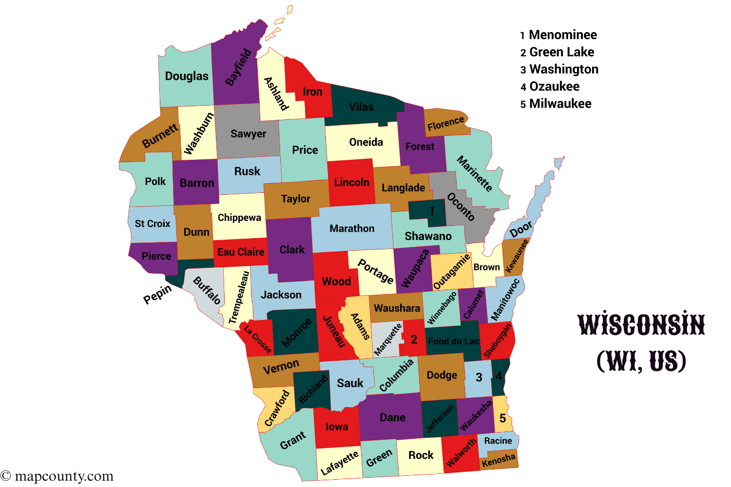
Wisconsin is organized into 72 counties. If you want clean, comparable geography for addresses, services, or data, counties are the easiest unit to start with. Each county has one county seat, the main location for core county offices and public records.
Wisconsin County Directory
Use this list to quickly match a county name with its county seat. It is handy for forms, trip planning, local lookups, and organizing regional notes.
| County | County Seat |
|---|---|
| Adams | Friendship |
| Ashland | Ashland |
| Barron | Barron |
| Bayfield | Washburn |
| Brown | Green Bay |
| Buffalo | Alma |
| Burnett | Siren |
| Calumet | Chilton |
| Chippewa | Chippewa Falls |
| Clark | Neillsville |
| Columbia | Portage |
| Crawford | Prairie du Chien |
| Dane | Madison |
| Dodge | Juneau |
| Door | Sturgeon Bay |
| Douglas | Superior |
| Dunn | Menomonie |
| Eau Claire | Eau Claire |
| Florence | Florence |
| Fond du Lac | Fond du Lac |
| Forest | Crandon |
| Grant | Lancaster |
| Green | Monroe |
| Green Lake | Green Lake |
| Iowa | Dodgeville |
| Iron | Hurley |
| Jackson | Black River Falls |
| Jefferson | Jefferson |
| Juneau | Mauston |
| Kenosha | Kenosha |
| Kewaunee | Kewaunee |
| La Crosse | La Crosse |
| Lafayette | Darlington |
| Langlade | Antigo |
| Lincoln | Merrill |
| Manitowoc | Manitowoc |
| Marathon | Wausau |
| Marinette | Marinette |
| Marquette | Montello |
| Menominee | Keshena |
| Milwaukee | Milwaukee |
| Monroe | Sparta |
| Oconto | Oconto |
| Oneida | Rhinelander |
| Outagamie | Appleton |
| Ozaukee | Port Washington |
| Pepin | Durand |
| Pierce | Ellsworth |
| Polk | Balsam Lake |
| Portage | Stevens Point |
| Price | Phillips |
| Racine | Racine |
| Richland | Richland Center |
| Rock | Janesville |
| Rusk | Ladysmith |
| Sauk | Baraboo |
| Sawyer | Hayward |
| Shawano | Shawano |
| Sheboygan | Sheboygan |
| St. Croix | Hudson |
| Taylor | Medford |
| Trempealeau | Whitehall |
| Vernon | Viroqua |
| Vilas | Eagle River |
| Walworth | Elkhorn |
| Washburn | Shell Lake |
| Washington | West Bend |
| Waukesha | Waukesha |
| Waupaca | Waupaca |
| Waushara | Wautoma |
| Winnebago | Oshkosh |
| Wood | Wisconsin Rapids |
How Counties Work In Wisconsin
A county is a mid level administrative area. Cities, villages, and towns can sit inside a county, but county boundaries do not change often, which makes them great for long term comparisons.
County Seat Basics
The county seat is the main hub for county adminstration, records, and many public facing offices. It is not always the largest city, but it is the place most people will reference when they need county level paperwork.
Why Counties Matter
- Consistency for maps and datasets
- Clarity for addresses and service areas
- Searchability when a place name is shared by multiple towns
- Planning for routes, deliveries, and regional coverage
County Level Data That Stays Useful
If you are comparing places across Wisconsin, these county metrics are popular because they remain meaningful over time. Some values change year to year, but the definitions stay stable.
| Metric | What It Helps You Do | Simple Tip |
|---|---|---|
| Land Area | Compare the physical size of counties | Pair with population to estimate density |
| Water Area | Understand lakes, rivers, and shoreline influence | Useful for recreation and seasonal planning |
| Population | Estimate demand, audience size, or reach | Look at trends across multiple years |
| Population Density | Spot urban vs rural patterns quickly | Do not assume density equals city size |
| Housing Units | Track growth and living patterns | Combine with vacancy rate for context |
| Median Age | Understand broad age profile | Use it alongside household size |
| Commuting Flow | See how counties connect economically | Helpful for regional, not local, decisions |
Fast Ways To Use The County List
Once you have the county and county seat, you can build clean workflows without digging through messy place name variations. Keep it simple, keep it consistent.
- Disambiguate places by pairing city name with county. Many names repeat across the Midwest.
- Standardize notes by always storing County, County Seat, and one main city.
- Group nearby counties for coverage planning, then drill down to municipalities only when needed.
- Sort alphabetically for a stable directory, then add your own tags like North, Central, or Southeast as you go.
Wisconsin Overview
Stable Facts
- State Capital: Madison
- Postal Abbreviation: WI
- Time Zone: Central Time
- County Count: 72
Geography Pointers
- Lake Michigan shapes the eastern shoreline counties
- The Mississippi River forms a scenic western edge
- Many northern counties feature dense forests and lakes
- Central counties often act as connectors for travel routes
Common County Questions
Is The County Seat Always The Biggest City
No. The county seat is the primary administrative hub. The largest city can be different, especially in counties with multiple strong local centers.
What Is The Best Way To Store County Data
Use three fields: County, County Seat, and Primary Place. Add optional tags like region or corridor later, but keep the core fields clean.
Why Do Counties Help With International Comparisons
Many countries use mid level units for services and statistics, even if the name changes. Counties are a simple, durable unit for organizing information beside provinces, regions, or districts.
More USA County Maps
- South Dakota County Map with Cities and Towns [SD, US]
- South Carolina County Map with Cities and Towns [SC, US]
- North Carolina County Map with Cities and Towns [NC, US]
- North Dakota County Map with Cities and Towns [ND, US]
- Wyoming County Map with Cities and Towns [WY, US]
- West Virginia County Map with Cities and Towns [WV, US]