✅Oregon County Map
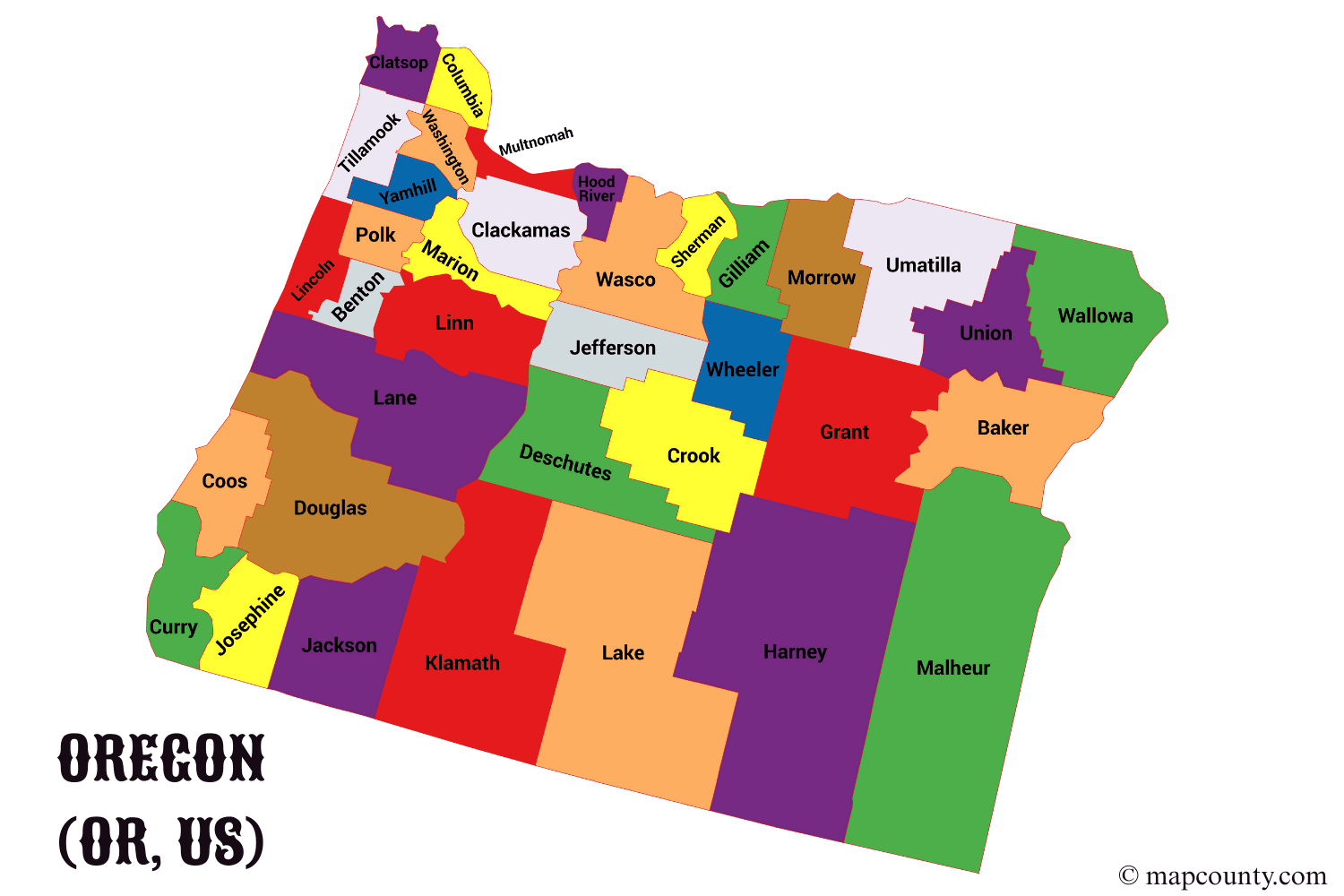
Oregon is divided into 36 counties. Each one has its own county seat, local services and landscape – from foggy Pacific beaches to high desert plateaus. Understanding these counties makes it much easier to read maps, plan trips, choose where to live or simply get a better feel for the state.
Below you will find a complete and practical overview of every county in Oregon, followed by an easy guide to regions, population centers and daily-life uses of county infromation.
Complete list of Oregon counties and county seats
This table lists all 36 counties in alphabetical order with their county seats and a short note that helps you remember what each area is like.
| County | County seat | General area type | Quick highlight |
|---|---|---|---|
| Baker County | Baker City | Eastern mountains & high desert | Historic mining heritage and scenic mountain valleys. |
| Benton County | Corvallis | Willamette Valley | College town life centered around Oregon State University. |
| Clackamas County | Oregon City | Portland metro & Cascade foothills | Mix of suburbs, farms and forested slopes near Mount Hood. |
| Clatsop County | Astoria | North Pacific coast | Historic mouth of the Columbia River and ocean beaches. |
| Columbia County | St. Helens | Columbia River corridor | Small communities along the river northwest of Portland. |
| Coos County | Coquille | South coast | Harbors, dunes and coastal forests near the Pacific. |
| Crook County | Prineville | Central Oregon high desert | Ranch country with canyons and growing outdoor recreation. |
| Curry County | Gold Beach | South coast | Rugged shoreline and wild rivers meeting the ocean. |
| Deschutes County | Bend | Central Oregon | Fast-growing outdoor hub with rivers, lava flows and ski areas. |
| Douglas County | Roseburg | Umpqua Valley & Cascades | Timber country, vineyards and forested river valleys. |
| Gilliam County | Condon | Columbia Plateau | Windy wheat fields and wide open horizons. |
| Grant County | Canyon City | Blue Mountains & high desert | Remote landscapes, forests and small ranching towns. |
| Harney County | Burns | High desert | Oregon’s largest county by area, with vast sagebrush basins. |
| Hood River County | Hood River | Columbia Gorge & Cascades | Orchards, wind sports and views of Mount Hood. |
| Jackson County | Medford | Southern Oregon & Rogue Valley | Warm valley climate, orchards and regional services. |
| Jefferson County | Madras | Central Oregon | High desert plateau with Cascade views and agriculture. |
| Josephine County | Grants Pass | Southern Oregon | Gateway to rivers, caves and forested hills. |
| Klamath County | Klamath Falls | Southern high plateau | Wetlands, lakes and access to Crater Lake area. |
| Lake County | Lakeview | High desert & lakes | Sparsely populated “Oregon Outback” with wide open skies. |
| Lane County | Eugene | Willamette Valley & coast range | University city framed by rivers, forests and nearby beaches. |
| Lincoln County | Newport | Central coast | Fishing harbors, headlands and year-round coastal towns. |
| Linn County | Albany | Willamette Valley | Farmland, timber and small cities along the I-5 corridor. |
| Malheur County | Vale | Far eastern Oregon | Agricultural lands and high desert near the Idaho border. |
| Marion County | Salem | Willamette Valley | Home to Salem, the state capital and a major service center. |
| Morrow County | Heppner | Columbia Plateau | Wind farms, ranches and Columbia River industry. |
| Multnomah County | Portland | Urban metro core | Oregon’s most populous county, centered on Portland. |
| Polk County | Dallas | Willamette Valley | Farms, vineyards and small college-town communities. |
| Sherman County | Moro | Columbia Plateau | Small population, wheat fields and Gorge viewpoints. |
| Tillamook County | Tillamook | North coast | Dairy farms, bays and heavily forested coastal hills. |
| Umatilla County | Pendleton | Columbia Plateau & Blue Mountains | Agriculture, historic towns and major transportation routes. |
| Union County | La Grande | Eastern mountains | Valleys ringed by peaks and a regional university. |
| Wallowa County | Enterprise | Northeast mountains | Dramatic Wallowa Mountains and deep glacial valleys. |
| Wasco County | The Dalles | Columbia Gorge | Historic trading center along the Columbia River. |
| Washington County | Hillsboro | Portland metro | High-tech “Silicon Forest” suburbs and fertile valleys. |
| Wheeler County | Fossil | High desert | Oregon’s least populated county, famous for fossil beds. |
| Yamhill County | McMinnville | Willamette Valley | Wine country landscapes and growing small cities. |
Key details about Oregon’s county system
- Number of counties: 36
- State population (2020): around 4.2 million people spread across those counties.
- Largest county by land area: Harney County, a huge high-desert region.
- Smallest county by land area: Multnomah County, but the most populated.
- State land area: about 96,000 square miles, making Oregon one of the larger U.S. states by size.
How Oregon counties work in daily life
When you look at a county map of Oregon, you are not just seeing lines. You are seeing how local government is organized: roads, courts, elections, land records, public health programs and more are often managed at the county level.
The county seat is the main administrative town or city. It usually hosts the courthouse, county offices and many regional services. Sometimes the county seat is the same as the largest city (like Portland in Multnomah County). In other cases, the seat is a smaller historic town while a nearby city has grown larger over time.
Why understanding counties is useful
- Moving or relocating? Counties help you compare school districts, housing markets and commute patterns.
- Traveling across Oregon? Planning by county makes it easier to group destinations, scenic drives and parks.
- Working with property or land? Deeds, zoning maps and many permits are handled at the county level.
- Researching local history? Archives, historic records and place-name stories are often organized by county.
- Enjoying the outdoors? Trail systems, campgrounds and recreation rules can change from one county to another.
From ocean to high desert: Oregon regions by county
Think of Oregon as a long band of landscapes stacked from west to east: Pacific Ocean, fertile valleys, tall mountains, and wide deserts. Each group of counties fits somewhere along this band.
Pacific coast counties
These counties touch the ocean or sit very close to it, shaped by marine weather, fishing and tourism:
- Clatsop (Astoria)
- Columbia (St. Helens, close to the lower Columbia River)
- Tillamook (Tillamook)
- Lincoln (Newport)
- Coos (Coquille)
- Curry (Gold Beach)
In these areas you often find small harbors, dairy farms, evergreen forests and towns wrapped around bays, inlets and river mouths. Stormy winters and mild summers are common along this stretch of coastline.
Willamette Valley counties
The central valley is Oregon’s most densely settled corridor. It runs roughly from Eugene to Portland and includes:
- Lane (Eugene)
- Linn (Albany)
- Benton (Corvallis)
- Marion (Salem)
- Polk (Dallas)
- Yamhill (McMinnville)
- Clackamas (Oregon City, partly metro, partly rural)
These counties are known for vineyards, farms, universities and major highways. If you picture green fields, gentle hills and mid-sized cities, you are probably thinking of the Willamette Valley enviroment.
Portland metro counties
The core metropolitan area covers three counties that are tightly linked by jobs, transit and suburbs:
- Multnomah (Portland)
- Washington (Hillsboro)
- Clackamas (Oregon City)
Here you will see dense neighborhoods, light-rail lines and a strong technology sector, especially in Washington County’s “Silicon Forest”. Multnomah County is compact in size but holds the largest share of Oregon’s residents.
Central Oregon & high desert counties
East of the Cascades, rainfall drops and the landscape opens into bright skies and sagebrush. Key counties here include:
- Deschutes (Bend)
- Crook (Prineville)
- Jefferson (Madras)
- Harney (Burns)
- Lake (Lakeview)
- Malheur (Vale)
- Gilliam (Condon)
- Sherman (Moro)
This is where many visitors go for skiing, mountain biking, river sports and stargazing. Towns are smaller, distances longer, and night skies darker than in the western part of the state.
Southern Oregon counties
- Jackson (Medford)
- Josephine (Grants Pass)
- Klamath (Klamath Falls)
- Douglas (Roseburg)
Southern Oregon blends river canyons, forests, agriculture and cultural events. Climate here can be warmer and drier than the Willamette Valley, which attracts people who like four distinct seasons but milder winters.
Northeast mountains & Columbia Plateau counties
- Baker (Baker City)
- Union (La Grande)
- Wallowa (Enterprise)
- Umatilla (Pendleton)
- Morrow (Heppner)
- Wasco (The Dalles)
These counties mix mountain ranges, deep canyons, wheat fields and river corridors. Some towns feel like classic frontier communities, with brick main streets and strong local traditions.
If you are moving
- Compare counties by commute distance and nearest county seat.
- Check which county your preferred school district sits in.
- Look at whether you want a valley, coastal or high-desert lifestyle.
If you are traveling
- Plan one trip around coastal counties and another around central Oregon.
- Use county lines to choose scenic byways and overnight stops.
- Check which county manages the parks or trails you want to visit.
Oregon as a whole: state-level overview
Across all 36 counties, Oregon covers about 96,000 square miles of land with a population a little above 4.2 million people. The state is long north-to-south and relatively narrow west-to-east, so many daily connections run along a few major corridors.
- Main north–south corridor: the I-5 highway passing through Douglas, Jackson, Josephine, Lane, Linn, Marion and Clackamas counties.
- Major metro cluster: Multnomah, Washington and Clackamas, centered on Portland and its suburbs.
- Valley corridor: a chain of cities from Eugene to Salem and up to the Portland area.
- Eastern routes: highways following the Columbia River and crossing high plateaus and basins.
Economically, different counties lean on different strengths: technology and services in the metro area, agriculture and vineyards in valley and plateau counties, timber and recreation in forested regions, and ranching in high-desert communities.
Climate and landscapes in simple terms
- Coastal counties: Cooler temperatures, more rain, ocean influence and evergreen forests.
- Valley counties: Mild winters, warm summers, fertile soils and many farms.
- Mountain & forest counties: Higher elevations, snow in winter, strong outdoor recreation focus.
- High-desert counties: Drier air, big daily temperature swings and wide open views.
Because of this variety, one map of Oregon counties is like a patchwork quilt of climates and lifestyles. You can drive just a few hours and move from temperate rainforests to dry plateaus.
Reading and using Oregon county maps effectively
Ever looked at a state map full of county names and felt a bit lost? With Oregon, a few simple habits turn that confusion into clarity.
- Start with the county seat: Find the bolded city that serves as the seat, then picture smaller towns spreading outward from there.
- Follow the rivers: Many county boundaries and communities line up with major rivers like the Columbia, Willamette or Rogue.
- Check the region: Ask, “Is this county on the coast, in the valley, in the mountains or in the desert?” That one question already tells you a lot.
- Notice size vs. population: Large high-desert counties can have very few people, while compact counties like Multnomah are densely settled.
- Match services to counties: When you look for courts, licenses or public records, always confirm which county your address belongs to.
Once you know the names, seats and basic character of each county, the map of Oregon stops being a flat picture. It becomes a living layout of communities, roads, rivers and opportunities that you can read and use with confidence, whether you are planning a move, a road trip or simply exploring the state from your desk.
More USA County Maps
- South Dakota County Map with Cities and Towns [SD, US]
- South Carolina County Map with Cities and Towns [SC, US]
- North Carolina County Map with Cities and Towns [NC, US]
- North Dakota County Map with Cities and Towns [ND, US]
- Wyoming County Map with Cities and Towns [WY, US]
- Wisconsin County Map with Cities and Towns [WI, US]