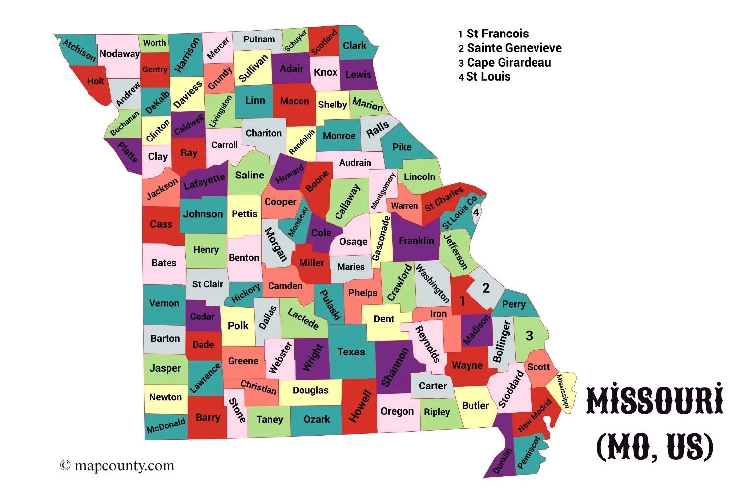
✅Missouri County Map
✅Missouri County List with Cities and Towns
| County Name | County Seat(s) | Major Cities & Towns |
|---|---|---|
| Adair | Kirksville | Kirksville |
| Andrew | Savannah | Savannah |
| Atchison | Rock Port | Rock Port, Tarkio |
| Audrain | Mexico | Mexico |
| Barry | Cassville | Cassville, Monett |
| Barton | Lamar | Lamar |
| Bates | Butler | Butler |
| Benton | Warsaw | Warsaw |
| Bollinger | Marble Hill | Marble Hill |
| Boone | Columbia | Columbia, Centralia, Ashland |
| Buchanan | St. Joseph | St. Joseph |
| Butler | Poplar Bluff | Poplar Bluff |
| Caldwell | Kingston | Hamilton, Cameron |
| Callaway | Fulton | Fulton, Holts Summit |
| Camden | Camdenton | Camdenton, Osage Beach |
| Cape Girardeau | Jackson | Cape Girardeau, Jackson |
| Carroll | Carrollton | Carrollton |
| Carter | Van Buren | Van Buren |
| Cass | Harrisonville | Harrisonville, Belton, Raymore |
| Cedar | Stockton | Stockton, El Dorado Springs |
| Chariton | Keytesville | Keytesville, Salisbury |
| Christian | Ozark | Ozark, Nixa, Republic |
| Clark | Kahoka | Kahoka |
| Clay | Liberty | Liberty, Kansas City, Gladstone |
| Clinton | Plattsburg | Plattsburg, Cameron |
| Cole | Jefferson City | Jefferson City |
| Cooper | Boonville | Boonville |
| Crawford | Steelville | Steelville, Cuba |
| Dade | Greenfield | Greenfield |
| Dallas | Buffalo | Buffalo |
| Daviess | Gallatin | Gallatin |
| DeKalb | Maysville | Maysville |
| Dent | Salem | Salem |
| Douglas | Ava | Ava |
| Dunklin | Kennett | Kennett, Malden |
| Franklin | Union | Union, Washington, Sullivan |
| Gasconade | Hermann | Hermann, Owensville |
| Gentry | Albany | Albany |
| Greene | Springfield | Springfield, Republic, Strafford |
| Grundy | Trenton | Trenton |
| Harrison | Bethany | Bethany |
| Henry | Clinton | Clinton, Windsor |
| Hickory | Hermitage | Hermitage |
| Holt | Oregon | Oregon, Mound City |
| Howard | Fayette | Fayette, Glasgow |
| Howell | West Plains | West Plains |
| Iron | Ironton | Ironton, Pilot Knob |
| Jackson | Independence | Kansas City, Independence, Lee’s Summit |
| Jasper | Carthage | Joplin, Carthage, Webb City |
| Jefferson | Hillsboro | Arnold, Festus, Hillsboro |
| Johnson | Warrensburg | Warrensburg, Knob Noster |
| Knox | Edina | Edina |
| Laclede | Lebanon | Lebanon |
| Lafayette | Lexington | Lexington, Odessa, Higginsville |
| Lawrence | Mount Vernon | Mount Vernon, Aurora, Marionville |
| Lewis | Monticello | Canton, La Grange |
| Lincoln | Troy | Troy, Wentzville (part) |
| Linn | Linneus | Brookfield, Marceline |
| Livingston | Chillicothe | Chillicothe |
| Macon | Macon | Macon |
| Madison | Fredericktown | Fredericktown |
| Maries | Vienna | Vienna |
| Marion | Palmyra | Hannibal, Palmyra |
| McDonald | Pineville | Pineville, Noel |
| Mercer | Princeton | Princeton |
| Miller | Tuscumbia | Eldon, Lake Ozark |
| Mississippi | Charleston | Charleston, East Prairie |
| Moniteau | California | California |
| Monroe | Paris | Paris, Monroe City |
| Montgomery | Montgomery City | Montgomery City |
| Morgan | Versailles | Versailles, Stover |
| New Madrid | New Madrid | New Madrid, Sikeston (part) |
| Newton | Neosho | Neosho, Joplin (part) |
| Nodaway | Maryville | Maryville |
| Oregon | Alton | Alton |
| Osage | Linn | Linn |
| Ozark | Gainesville | Gainesville |
| Pemiscot | Caruthersville | Caruthersville, Hayti |
| Perry | Perryville | Perryville |
| Pettis | Sedalia | Sedalia |
| Phelps | Rolla | Rolla, St. James |
| Pike | Bowling Green | Bowling Green, Louisiana |
| Platte | Platte City | Platte City, Parkville, Kansas City (part) |
| Polk | Bolivar | Bolivar |
| Pulaski | Waynesville | Waynesville, St. Robert, Fort Leonard Wood |
| Putnam | Unionville | Unionville |
| Ralls | New London | New London, Hannibal (part) |
| Randolph | Huntsville | Moberly, Huntsville |
| Ray | Richmond | Richmond, Lawson |
| Reynolds | Centerville | Centerville, Ellington |
| Ripley | Doniphan | Doniphan |
| Saline | Marshall | Marshall |
| Schuyler | Lancaster | Lancaster |
| Scotland | Memphis | Memphis |
| Scott | Benton | Sikeston, Scott City |
| Shannon | Eminence | Eminence, Winona |
| Shelby | Shelbyville | Shelbina, Shelbyville |
| St. Charles | St. Charles | O’Fallon, St. Charles, St. Peters, Wentzville |
| St. Clair | Osceola | Osceola, Appleton City |
| St. Francois | Farmington | Farmington, Park Hills, Desloge |
| Ste. Genevieve | Ste. Genevieve | Ste. Genevieve |
| St. Louis (County) | Clayton | Florissant, Chesterfield, Wildwood, Clayton |
| St. Louis (City) | St. Louis | (Independent City) |
| Stoddard | Bloomfield | Dexter, Bloomfield |
| Stone | Galena | Branson West, Kimberling City |
| Sullivan | Milan | Milan |
| Taney | Forsyth | Branson, Forsyth |
| Texas | Houston | Houston, Licking, Cabool |
| Vernon | Nevada | Nevada |
| Warren | Warrenton | Warrenton, Wright City |
| Washington | Potosi | Potosi |
| Wayne | Greenville | Greenville, Piedmont |
| Webster | Marshfield | Marshfield, Rogersville |
| Worth | Grant City | Grant City |
| Wright | Hartville | Hartville, Mountain Grove |
A Guide to Missouri’s Counties
Welcome to Missouri, a state where Midwestern prairies meet Southern highlands. To understand its geography and culture, it’s important to first look at its structure: 114 counties and one independent city, St. Louis, which acts as a county. This setup is the foundation for local government, community identity, and record-keeping throughout the state.
From the bustling metropolitan areas of Kansas City and St. Louis to the rolling hills of the Ozarks, each county has a unique story. These counties are home to hundreds of municipalities, which are classified under Missouri law, generally by population:
- Villages: Typically municipalities with fewer than 500 residents.
- Fourth Class Cities: Generally those with a population between 500 and 2,999.
- Third Class Cities: Generally those with a population between 3,000 and 29,999.
- Charter Cities: Larger cities (like Kansas City, St. Louis, and Springfield) that operate under their own unique constitutional charter, allowing for more flexible governance.
This guide includes a list of all 115 county-equivalents, their county seats (local government centers), and some of the main cities and towns that give them their identity. Note: The “Major Cities & Towns” column includes important populated places, but is not a complete list.
A Journey Through Missouri’s Regions
A county map is also a map of Missouri’s distinct geographic personalities. The state is dramatically split by the Missouri River, which creates its two best-known regions:
- Northern Plains (Dissected Till Plains): North of the river, you find the rolling hills and fertile farmland of the Dissected Till Plains. This is classic Midwest farm country, with counties like Adair, Nodaway, and Linn.
- The Ozark Plateau: South of the river, the landscape rises into the Ozark Plateau (or Ozark Highlands). This is a vast region of forests, springs, caves, and rugged hills, covering much of southern Missouri, including counties like Texas, Shannon, and Taney (home to Branson).
Other key regions include:
- The Osage Plains: A flat, prairie-like extension of Kansas covering western counties like Barton and Vernon.
- The Mississippi Lowlands (Bootheel): In the far southeastern corner, the “Bootheel” is a flat, alluvial plain, culturally and geographically more like the Mississippi Delta. It is the state’s primary cotton-growing region, in counties such as Pemiscot and Dunklin.
- The Alluvial River Plain: The flat, fertile floodplains bordering the Missouri and Mississippi Rivers, which are home to the state’s largest urban centers, including St. Louis, Kansas City, and the capital, Jefferson City.
Why the County Map is Your Most Valuable Tool
Understanding this map is the key to unlocking Missouri. All vital records, public services, and legal matters are handled at the county level.
For genealogists and historians, the county courthouse is the primary source. Marriage licenses, land deeds, court records, and birth/death certificates are all filed in the county where the event occurred. The historic boundaries of counties like Cape Girardeau and St. Louis, two of the state’s original five, tell the story of Missouri’s westward expansion.
For travelers and residents, the map is a guide to local culture. It helps you navigate from the wineries in Gasconade County, to the history in Marion County (Hannibal), to the outdoor recreation in the Ozark counties, and to the major economic hubs of St. Louis, Jackson, and Greene counties.
Sources
For the best information, we recommend these official government and university resources for your research:
- Missouri Census Data Center (MCDC): Operated by the University of Missouri, this is a primary source for detailed population, housing, and economic data for every county and city.https://mcdc.missouri.edu/
- Missouri Secretary of State – County Classifications: This page details the official legal classifications for all 114 Missouri counties.https://www.sos.mo.gov/BlueBook/2021-2022/8_Counties.pdf (Note: Link may update with new “Blue Book” editions)
- University of Missouri Extension – County Offices: A practical directory of all county extension offices, which are hubs for local agricultural, community, and economic information.https://extension.missouri.edu/locations
- U.S. Census Bureau – Missouri QuickFacts: A trusted source for demographic and economic statistics, easily compared by county.https://www.census.gov/quickfacts/fact/table/MO/PST045223
More USA County Maps
- South Dakota County Map with Cities and Towns [SD, US]
- South Carolina County Map with Cities and Towns [SC, US]
- North Carolina County Map with Cities and Towns [NC, US]
- North Dakota County Map with Cities and Towns [ND, US]
- Wyoming County Map with Cities and Towns [WY, US]
- Wisconsin County Map with Cities and Towns [WI, US]