California, with its 58 counties, has a unique administrative structure. From the tall redwoods in the north to the sunny beaches in the south, each county offers its own story of geography, culture, and growth. This guide looks at California’s county system and the features that make each area stand out.
✅California County Map
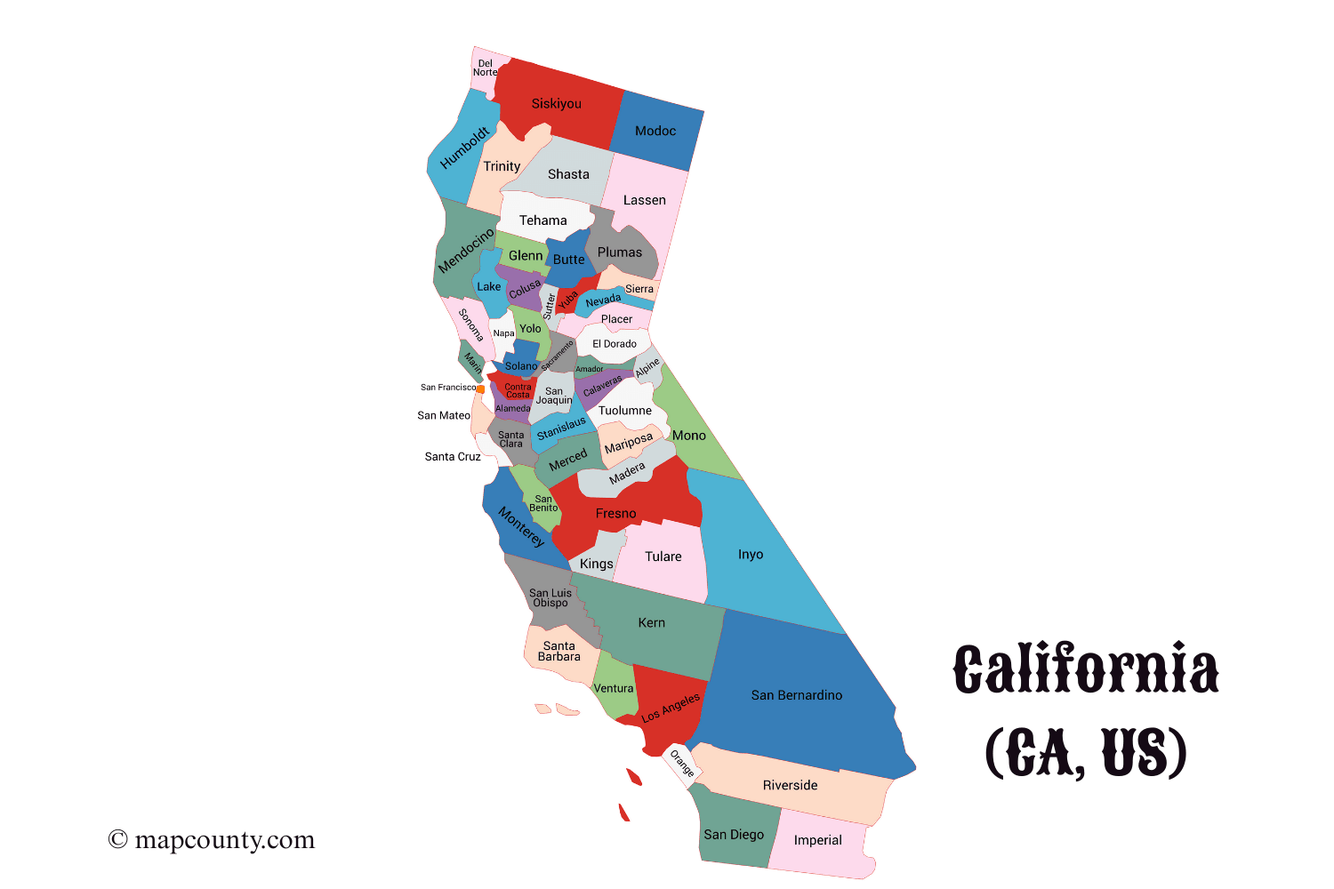
✅ “California Counties: Seats, Cities, Dates & Area (Full List)”
| County | County Seat | Major Cities/Towns | Incorporation Date | Area (sq mi) |
|---|---|---|---|---|
| Alameda | Oakland | Berkeley, Fremont, Hayward | 1853 | 821 |
| Alpine | Markleeville | Woodfords | 1864 | 743 |
| Amador | Jackson | Ione, Sutter Creek | 1854 | 606 |
| Butte | Oroville | Chico, Paradise | 1850 | 1,677 |
| Calaveras | San Andreas | Angels Camp, Mokelumne Hill | 1850 | 1,037 |
| Colusa | Colusa | Williams, Princeton | 1850 | 1,156 |
| Contra Costa | Martinez | Concord, Walnut Creek, Richmond | 1850 | 804 |
| Del Norte | Crescent City | Klamath | 1857 | 1,006 |
| El Dorado | Placerville | South Lake Tahoe | 1850 | 1,786 |
| Fresno | Fresno | Clovis, Sanger | 1856 | 6,011 |
| Glenn | Willows | Orland | 1891 | 1,315 |
| Humboldt | Eureka | Arcata, Fortuna | 1853 | 3,568 |
| Imperial | El Centro | Brawley, Calexico | 1907 | 4,482 |
| Inyo | Independence | Bishop, Lone Pine | 1866 | 10,227 |
| Kern | Bakersfield | Delano, Tehachapi | 1866 | 8,163 |
| Kings | Hanford | Lemoore | 1893 | 1,392 |
| Lake | Lakeport | Clearlake | 1861 | 1,329 |
| Lassen | Susanville | Herlong | 1864 | 4,720 |
| Los Angeles | Los Angeles | Long Beach, Santa Monica, Pasadena | 1850 | 4,751 |
| Madera | Madera | Oakhurst, Chowchilla | 1893 | 2,153 |
| Marin | San Rafael | Mill Valley, Novato | 1850 | 828 |
| Mariposa | Mariposa | Yosemite | 1850 | 1,463 |
| Mendocino | Ukiah | Fort Bragg | 1850 | 3,878 |
| Merced | Merced | Los Banos, Atwater | 1855 | 1,979 |
| Modoc | Alturas | Adin | 1874 | 4,203 |
| Mono | Mammoth Lakes | Bodie | 1861 | 3,030 |
| Monterey | Salinas | Carmel-by-the-Sea, Monterey | 1850 | 3,771 |
| Napa | Napa | St. Helena, Calistoga | 1850 | 789 |
| Nevada | Nevada City | Grass Valley | 1851 | 974 |
| Orange | Santa Ana | Irvine, Anaheim, Huntington Beach | 1889 | 948 |
| Placer | Auburn | Roseville, Lincoln | 1851 | 1,502 |
| Plumas | Quincy | Greenville | 1854 | 2,613 |
| Riverside | Riverside | Palm Springs, Moreno Valley | 1893 | 7,303 |
| Sacramento | Sacramento | Folsom, Elk Grove | 1850 | 994 |
| San Benito | Hollister | Paicines | 1874 | 1,390 |
| San Bernardino | San Bernardino | Ontario, Rancho Cucamonga | 1853 | 20,105 |
| San Diego | San Diego | Chula Vista, Escondido | 1850 | 4,526 |
| San Francisco | San Francisco | — | 1850 | 47 |
| San Joaquin | Stockton | Lodi, Manteca | 1850 | 1,426 |
| San Luis Obispo | San Luis Obispo | Paso Robles, Morro Bay | 1850 | 3,616 |
| San Mateo | Redwood City | South San Francisco, Daly City | 1856 | 448 |
| Santa Barbara | Santa Barbara | Santa Maria, Lompoc | 1850 | 3,789 |
| Santa Clara | San Jose | Sunnyvale, Mountain View | 1850 | 1,304 |
| Santa Cruz | Santa Cruz | Watsonville, Capitola | 1850 | 445 |
| Shasta | Redding | Anderson, Shasta Lake | 1850 | 3,847 |
| Sierra | Downieville | — | 1852 | 962 |
| Siskiyou | Yreka | Mount Shasta | 1852 | 6,347 |
| Solano | Fairfield | Vallejo, Vacaville | 1850 | 906 |
| Sonoma | Santa Rosa | Petaluma, Healdsburg | 1850 | 1,576 |
| Stanislaus | Modesto | Turlock, Ceres | 1854 | 1,515 |
| Sutter | Yuba City | Live Oak | 1850 | 608 |
| Tehama | Red Bluff | Corning | 1856 | 2,962 |
| Trinity | Weaverville | — | 1850 | 3,208 |
| Tulare | Visalia | Porterville, Dinuba | 1852 | 4,839 |
| Tuolumne | Sonora | Jamestown, Twain Harte | 1850 | 2,274 |
| Ventura | Ventura | Oxnard, Thousand Oaks | 1872 | 1,843 |
| Yolo | Woodland | Davis, West Sacramento | 1850 | 1,021 |
| Yuba | Marysville | Lone Tree | 1850 | 630 |
California County Map: The Golden State’s Diverse Regions
California, with its 58 counties, has a distinctive administrative system. From the tall redwoods in the north to the sunny beaches in the south, each county has its own history of geography, culture, and growth. This guide looks at California’s county system and the features that make each area stand out.
Administrative Structure
California’s county system was established when the state joined the Union in 1850. The original 27 counties have since expanded to 58, each with its own local government structure. Counties serve as the primary administrative divisions between the state government and municipal authorities, providing essential services including law enforcement, public health, education, and infrastructure maintenance.
Unlike many states, California includes both general law counties and charter counties. The majority operate under general law, following state-mandated structures, while 14 counties (including Los Angeles, San Francisco, and Sacramento) have adopted charters that grant them greater autonomy in governance.
Geographic Diversity
California’s counties span an incredible range of geographic features, from the highest point in the contiguous United States (Mount Whitney in Inyo County) to the lowest point (Death Valley in Inyo and San Bernardino counties). The state’s diverse topography includes:
- Coastal Regions: 27 counties border the Pacific Ocean, featuring everything from dramatic cliffs to expansive beaches
- Mountain Territories: Sierra Nevada counties like Plumas, Sierra, and Mono feature alpine environments and world-class ski resorts
- Desert Areas: Southern and eastern counties including Imperial, Riverside, and San Bernardino contain vast desert landscapes
- Agricultural Heartlands: The Central Valley counties (Fresno, Kern, Tulare) form one of the world’s most productive agricultural regions
- Urban Centers: Metropolitan counties like Los Angeles, San Francisco, and San Diego support dense population centers
Population Distribution
California’s population distribution reveals fascinating patterns of settlement and development. Los Angeles County stands as the most populous county in the United States, with over 10 million residents—more than the individual populations of 41 states. Meanwhile, Alpine County, with fewer than 1,200 residents, represents the state’s least populated county.
This population disparity highlights California’s unique urban-rural divide. While coastal urban counties contain the majority of residents, the state’s vast interior features sparsely populated regions with distinct cultures and economies.
Economic Specializations
Each California county has developed unique economic specializations based on geographic advantages and historical development:
- Technology Hubs: Santa Clara County (Silicon Valley) leads global technology innovation
- Agricultural Powerhouses: Central Valley counties dominate American agricultural production
- Entertainment Centers: Los Angeles County remains the heart of the global entertainment industry
- Wine Regions: Napa, Sonoma, and Mendocino counties form world-renowned wine production areas
- Tourism Destinations: Orange, San Diego, and San Francisco counties attract millions of visitors annually
Cultural Regions
California’s counties cluster into distinct cultural regions that reflect historical settlement patterns and geographic influences:
Northern California
The northern counties, particularly those along the North Coast and in the Sierra Nevada, maintain a distinct identity shaped by logging, fishing, and mining histories. This region features smaller communities with strong connections to natural resources.
Bay Area
The nine-county San Francisco Bay Area represents a unique cultural and economic region characterized by technological innovation, progressive politics, and diverse populations. This region functions as an interconnected metropolitan area while maintaining distinct county identities.
Central Valley
Stretching over 450 miles, the Central Valley counties share agricultural roots and face common challenges related to water management, labor issues, and economic diversification.
Southern California
The southern counties, particularly those in the Los Angeles Basin and San Diego area, developed around different growth patterns than Northern California, with more decentralized development and car-oriented infrastructure.
Historical Development
California’s county map has evolved significantly since statehood. The original 27 counties established in 1850 have been subdivided and reorganized as population grew and transportation improved. Key developments in county formation include:
- Gold Rush Era: The initial county system established to manage the rapid population influx
- Railroad Expansion: County formation followed railroad development in the late 19th century
- 20th Century Suburbanization: Southern California counties expanded with automotive suburbs
- Recent Developments: The last county formation was in 1907 (Imperial County), though boundary adjustments continue
Unique County Features
Several California counties possess unique characteristics worth noting:
- San Francisco: The only consolidated city-county in California, functioning as both a city and county
- Alpine: The smallest county by population, with no traffic signals or incorporated cities
- Los Angeles: The most populous county in the United States, with a economy larger than most countries
- Inyo: Contains both the highest and lowest points in the contiguous United States
- Mono: Home to the oldest living trees on earth, the ancient bristlecone pines
Challenges and Opportunities
California’s counties face numerous contemporary challenges, including:
- Water Management: Particularly critical for agricultural counties
- Wildfire Management: Forested counties face increasing wildfire risks
- Housing Affordability: Urban counties struggle with housing costs
- Economic Transition: Resource-dependent counties seek economic diversification
- Climate Change: Coastal counties face sea-level rise while inland counties confront extreme heat
Despite these challenges, California counties continue to innovate in governance, environmental protection, and economic development, often serving as policy laboratories for the nation.
Conclusion
California’s county system manages a wide range of diversity in geography, economy, and culture. From the tech hubs of Silicon Valley to the farms of the Central Valley, from the entertainment industry in Los Angeles to the vineyards in Napa, each county plays a part in what makes California special.
Looking at California through its county system shows how different regions can work together within a single government while keeping their own character and handling specific challenges. As California grows, its counties will continue to play a key role in governance, community identity, and local development.
More USA County Maps
- South Dakota County Map with Cities and Towns [SD, US]
- South Carolina County Map with Cities and Towns [SC, US]
- North Carolina County Map with Cities and Towns [NC, US]
- North Dakota County Map with Cities and Towns [ND, US]
- Wyoming County Map with Cities and Towns [WY, US]
- Wisconsin County Map with Cities and Towns [WI, US]